You are here: Home > Network List > TA - USArray Transportable Network (new EarthScope stations) Stations List
> Station 121A Cookes Peak, Deming, NM, USA > Earthquake Result Viewer
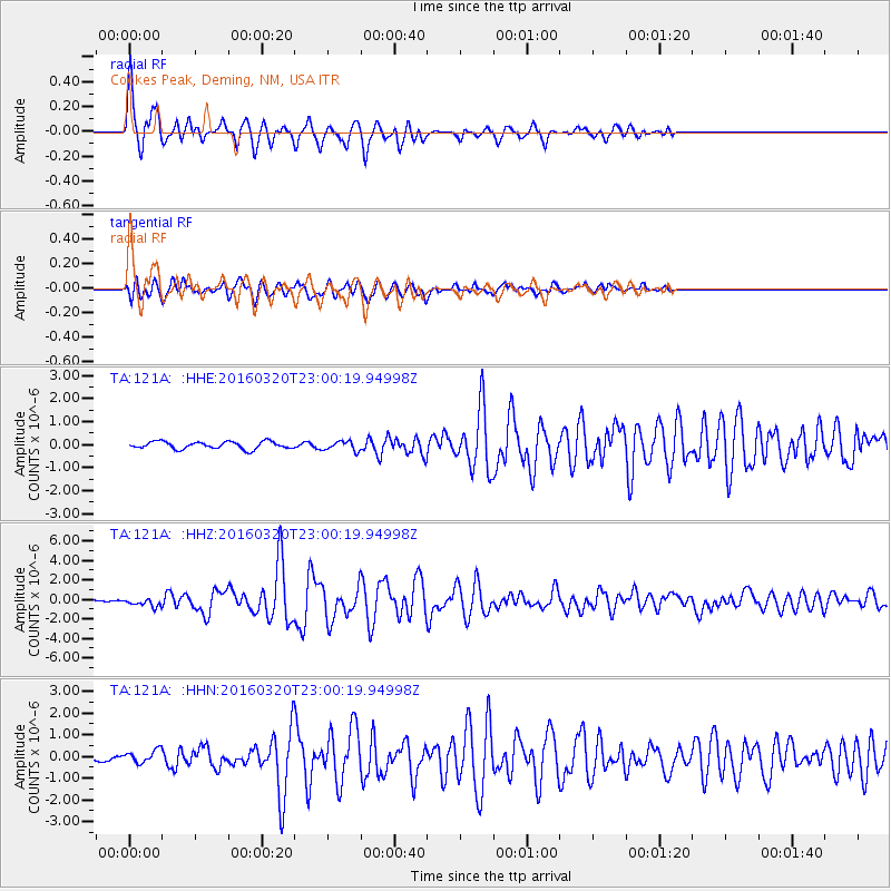
121A Cookes Peak, Deming, NM, USA - Earthquake Result Viewer
| Earthquake location: |
Near East Coast Of Kamchatka |
| Earthquake latitude/longitude: |
54.3/162.8 |
| Earthquake time(UTC): |
2016/03/20 (080) 22:50:20 GMT |
| Earthquake Depth: |
31 km |
| Earthquake Magnitude: |
6.4 MWC, 6.2 MWB, 6.6 MI |
| Earthquake Catalog/Contributor: |
NEIC PDE/NEIC COMCAT |
|
| Network: |
TA USArray Transportable Network (new EarthScope stations) |
| Station: |
121A Cookes Peak, Deming, NM, USA |
| Lat/Lon: |
32.53 N/107.79 W |
| Elevation: |
1652 m |
|
| Distance: |
64.0 deg |
| Az: |
70.058 deg |
| Baz: |
319.326 deg |
| Ray Param: |
0.05917864 |
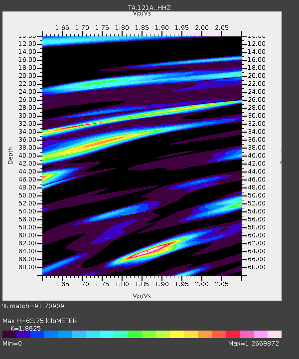
| Estimated Moho Depth: |
63.75 km |
| Estimated Crust Vp/Vs: |
1.86 |
| Assumed Crust Vp: |
6.502 km/s |
| Estimated Crust Vs: |
3.491 km/s |
| Estimated Crust Poisson's Ratio: |
0.30 |
|
| Radial Match: |
91.70909 % |
| Radial Bump: |
400 |
| Transverse Match: |
86.2717 % |
| Transverse Bump: |
400 |
| SOD ConfigId: |
7422571 |
| Insert Time: |
2019-04-22 02:12:29.334 +0000 |
| GWidth: |
2.5 |
| Max Bumps: |
400 |
| Tol: |
0.001 |
|
Signal To Noise
| Channel | StoN | STA | LTA |
| TA:121A: :HHZ:20160320T23:00:19.94998Z | 2.7334106 | 4.1287558E-7 | 1.5104777E-7 |
| TA:121A: :HHN:20160320T23:00:19.94998Z | 2.3228161 | 3.042803E-7 | 1.3099628E-7 |
| TA:121A: :HHE:20160320T23:00:19.94998Z | 1.2407717 | 1.9690461E-7 | 1.5869527E-7 |
| Arrivals |
| Ps | 8.8 SECOND |
| PpPs | 27 SECOND |
| PsPs/PpSs | 36 SECOND |


