You are here: Home > Network List > TA - USArray Transportable Network (new EarthScope stations) Stations List
> Station G05D Wamic, OR, USA > Earthquake Result Viewer
G05D Wamic, OR, USA - Earthquake Result Viewer
| Earthquake location: |
Near East Coast Of Kamchatka |
| Earthquake latitude/longitude: |
54.3/162.8 |
| Earthquake time(UTC): |
2016/03/20 (080) 22:50:20 GMT |
| Earthquake Depth: |
31 km |
| Earthquake Magnitude: |
6.4 MWC, 6.2 MWB, 6.6 MI |
| Earthquake Catalog/Contributor: |
NEIC PDE/NEIC COMCAT |
|
| Network: |
TA USArray Transportable Network (new EarthScope stations) |
| Station: |
G05D Wamic, OR, USA |
| Lat/Lon: |
45.24 N/121.32 W |
| Elevation: |
592 m |
|
| Distance: |
47.6 deg |
| Az: |
68.143 deg |
| Baz: |
309.701 deg |
| Ray Param: |
0.06983967 |
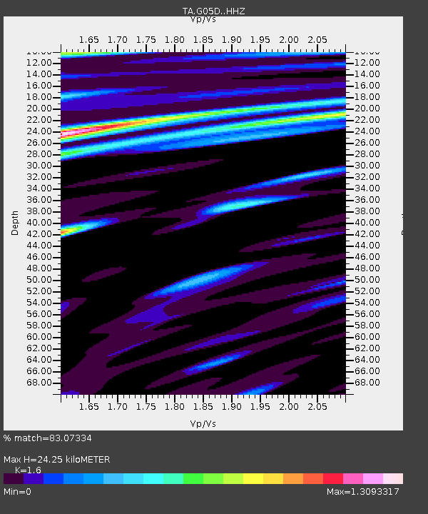
| Estimated Moho Depth: |
24.25 km |
| Estimated Crust Vp/Vs: |
1.60 |
| Assumed Crust Vp: |
6.597 km/s |
| Estimated Crust Vs: |
4.123 km/s |
| Estimated Crust Poisson's Ratio: |
0.18 |
|
| Radial Match: |
83.07334 % |
| Radial Bump: |
378 |
| Transverse Match: |
72.526344 % |
| Transverse Bump: |
400 |
| SOD ConfigId: |
7422571 |
| Insert Time: |
2019-04-22 02:12:42.497 +0000 |
| GWidth: |
2.5 |
| Max Bumps: |
400 |
| Tol: |
0.001 |
|

Signal To Noise
| Channel | StoN | STA | LTA |
| TA:G05D: :HHZ:20160320T22:58:22.73001Z | 3.0148282 | 1.7448904E-6 | 5.7876946E-7 |
| TA:G05D: :HHN:20160320T22:58:22.73001Z | 0.87229407 | 8.049443E-7 | 9.2279004E-7 |
| TA:G05D: :HHE:20160320T22:58:22.73001Z | 0.6575624 | 4.6712893E-7 | 7.1039483E-7 |
| Arrivals |
| Ps | 2.4 SECOND |
| PpPs | 8.9 SECOND |
| PsPs/PpSs | 11 SECOND |


