You are here: Home > Network List > TA - USArray Transportable Network (new EarthScope stations) Stations List
> Station J29M Klondike Camp, Yukon, CA > Earthquake Result Viewer
J29M Klondike Camp, Yukon, CA - Earthquake Result Viewer
| Earthquake location: |
Near East Coast Of Kamchatka |
| Earthquake latitude/longitude: |
54.3/162.8 |
| Earthquake time(UTC): |
2016/03/20 (080) 22:50:20 GMT |
| Earthquake Depth: |
31 km |
| Earthquake Magnitude: |
6.4 MWC, 6.2 MWB, 6.6 MI |
| Earthquake Catalog/Contributor: |
NEIC PDE/NEIC COMCAT |
|
| Network: |
TA USArray Transportable Network (new EarthScope stations) |
| Station: |
J29M Klondike Camp, Yukon, CA |
| Lat/Lon: |
64.45 N/138.22 W |
| Elevation: |
982 m |
|
| Distance: |
30.5 deg |
| Az: |
46.991 deg |
| Baz: |
279.005 deg |
| Ray Param: |
0.07927572 |
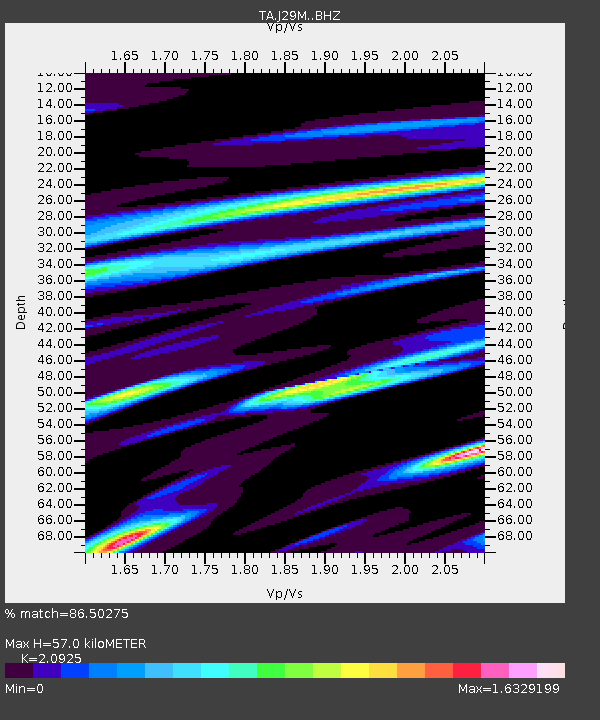
| Estimated Moho Depth: |
57.0 km |
| Estimated Crust Vp/Vs: |
2.09 |
| Assumed Crust Vp: |
6.566 km/s |
| Estimated Crust Vs: |
3.138 km/s |
| Estimated Crust Poisson's Ratio: |
0.35 |
|
| Radial Match: |
86.50275 % |
| Radial Bump: |
400 |
| Transverse Match: |
67.290955 % |
| Transverse Bump: |
400 |
| SOD ConfigId: |
7422571 |
| Insert Time: |
2019-04-22 02:12:49.421 +0000 |
| GWidth: |
2.5 |
| Max Bumps: |
400 |
| Tol: |
0.001 |
|

Signal To Noise
| Channel | StoN | STA | LTA |
| TA:J29M: :BHZ:20160320T22:56:00.999999Z | 3.6549065 | 6.148754E-7 | 1.6823286E-7 |
| TA:J29M: :BHN:20160320T22:56:00.999999Z | 1.3608007 | 2.8311243E-7 | 2.080484E-7 |
| TA:J29M: :BHE:20160320T22:56:00.999999Z | 2.5129087 | 5.9234503E-7 | 2.3572088E-7 |
| Arrivals |
| Ps | 10 SECOND |
| PpPs | 25 SECOND |
| PsPs/PpSs | 35 SECOND |


