You are here: Home > Network List > TA - USArray Transportable Network (new EarthScope stations) Stations List
> Station M31M Drury Creek, Yukon, CA > Earthquake Result Viewer
M31M Drury Creek, Yukon, CA - Earthquake Result Viewer
| Earthquake location: |
Near East Coast Of Kamchatka |
| Earthquake latitude/longitude: |
54.3/162.8 |
| Earthquake time(UTC): |
2016/03/20 (080) 22:50:20 GMT |
| Earthquake Depth: |
31 km |
| Earthquake Magnitude: |
6.4 MWC, 6.2 MWB, 6.6 MI |
| Earthquake Catalog/Contributor: |
NEIC PDE/NEIC COMCAT |
|
| Network: |
TA USArray Transportable Network (new EarthScope stations) |
| Station: |
M31M Drury Creek, Yukon, CA |
| Lat/Lon: |
62.20 N/134.39 W |
| Elevation: |
639 m |
|
| Distance: |
32.7 deg |
| Az: |
50.505 deg |
| Baz: |
285.412 deg |
| Ray Param: |
0.07849068 |
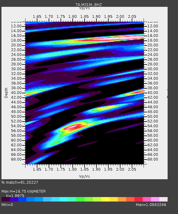
| Estimated Moho Depth: |
16.75 km |
| Estimated Crust Vp/Vs: |
2.00 |
| Assumed Crust Vp: |
6.419 km/s |
| Estimated Crust Vs: |
3.214 km/s |
| Estimated Crust Poisson's Ratio: |
0.33 |
|
| Radial Match: |
91.20227 % |
| Radial Bump: |
400 |
| Transverse Match: |
81.98989 % |
| Transverse Bump: |
400 |
| SOD ConfigId: |
7422571 |
| Insert Time: |
2019-04-22 02:12:58.228 +0000 |
| GWidth: |
2.5 |
| Max Bumps: |
400 |
| Tol: |
0.001 |
|

Signal To Noise
| Channel | StoN | STA | LTA |
| TA:M31M: :BHZ:20160320T22:56:19.975005Z | 9.436193 | 1.4609454E-6 | 1.548236E-7 |
| TA:M31M: :BHN:20160320T22:56:19.975005Z | 2.122352 | 3.0964424E-7 | 1.4589675E-7 |
| TA:M31M: :BHE:20160320T22:56:19.975005Z | 8.156122 | 9.156315E-7 | 1.1226309E-7 |
| Arrivals |
| Ps | 2.8 SECOND |
| PpPs | 7.3 SECOND |
| PsPs/PpSs | 10 SECOND |


