You are here: Home > Network List > TA - USArray Transportable Network (new EarthScope stations) Stations List
> Station MDND Maddock, ND, USA > Earthquake Result Viewer
MDND Maddock, ND, USA - Earthquake Result Viewer
| Earthquake location: |
Near East Coast Of Kamchatka |
| Earthquake latitude/longitude: |
54.3/162.8 |
| Earthquake time(UTC): |
2016/03/20 (080) 22:50:20 GMT |
| Earthquake Depth: |
31 km |
| Earthquake Magnitude: |
6.4 MWC, 6.2 MWB, 6.6 MI |
| Earthquake Catalog/Contributor: |
NEIC PDE/NEIC COMCAT |
|
| Network: |
TA USArray Transportable Network (new EarthScope stations) |
| Station: |
MDND Maddock, ND, USA |
| Lat/Lon: |
47.85 N/99.60 W |
| Elevation: |
479 m |
|
| Distance: |
56.8 deg |
| Az: |
52.893 deg |
| Baz: |
316.098 deg |
| Ray Param: |
0.06382215 |
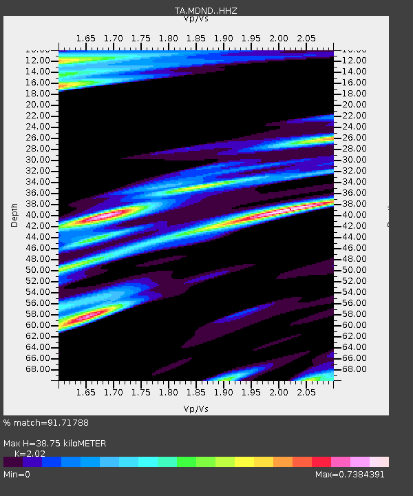
| Estimated Moho Depth: |
38.75 km |
| Estimated Crust Vp/Vs: |
2.02 |
| Assumed Crust Vp: |
6.53 km/s |
| Estimated Crust Vs: |
3.233 km/s |
| Estimated Crust Poisson's Ratio: |
0.34 |
|
| Radial Match: |
91.71788 % |
| Radial Bump: |
309 |
| Transverse Match: |
84.91153 % |
| Transverse Bump: |
400 |
| SOD ConfigId: |
7422571 |
| Insert Time: |
2019-04-22 02:13:01.679 +0000 |
| GWidth: |
2.5 |
| Max Bumps: |
400 |
| Tol: |
0.001 |
|
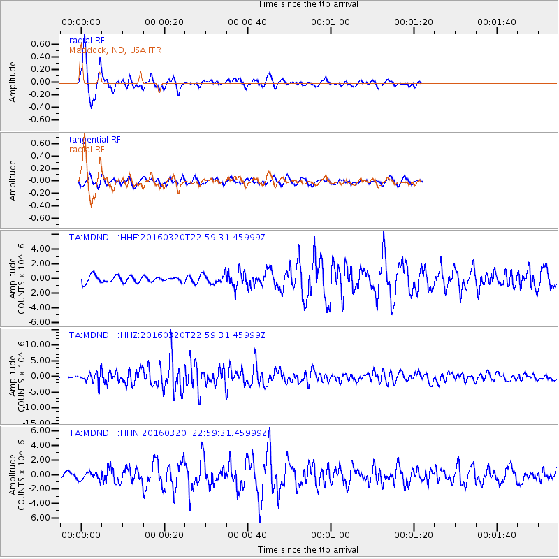
Signal To Noise
| Channel | StoN | STA | LTA |
| TA:MDND: :HHZ:20160320T22:59:31.45999Z | 11.411651 | 1.7894845E-6 | 1.5681206E-7 |
| TA:MDND: :HHN:20160320T22:59:31.45999Z | 1.4842442 | 5.4407525E-7 | 3.665672E-7 |
| TA:MDND: :HHE:20160320T22:59:31.45999Z | 1.4624115 | 6.3559986E-7 | 4.3462452E-7 |
| Arrivals |
| Ps | 6.3 SECOND |
| PpPs | 17 SECOND |
| PsPs/PpSs | 23 SECOND |


