You are here: Home > Network List > TA - USArray Transportable Network (new EarthScope stations) Stations List
> Station O48B Farmland, IN, USA > Earthquake Result Viewer
O48B Farmland, IN, USA - Earthquake Result Viewer
| Earthquake location: |
Near East Coast Of Kamchatka |
| Earthquake latitude/longitude: |
54.3/162.8 |
| Earthquake time(UTC): |
2016/03/20 (080) 22:50:20 GMT |
| Earthquake Depth: |
31 km |
| Earthquake Magnitude: |
6.4 MWC, 6.2 MWB, 6.6 MI |
| Earthquake Catalog/Contributor: |
NEIC PDE/NEIC COMCAT |
|
| Network: |
TA USArray Transportable Network (new EarthScope stations) |
| Station: |
O48B Farmland, IN, USA |
| Lat/Lon: |
40.26 N/85.16 W |
| Elevation: |
300 m |
|
| Distance: |
69.3 deg |
| Az: |
49.314 deg |
| Baz: |
324.527 deg |
| Ray Param: |
0.05569363 |
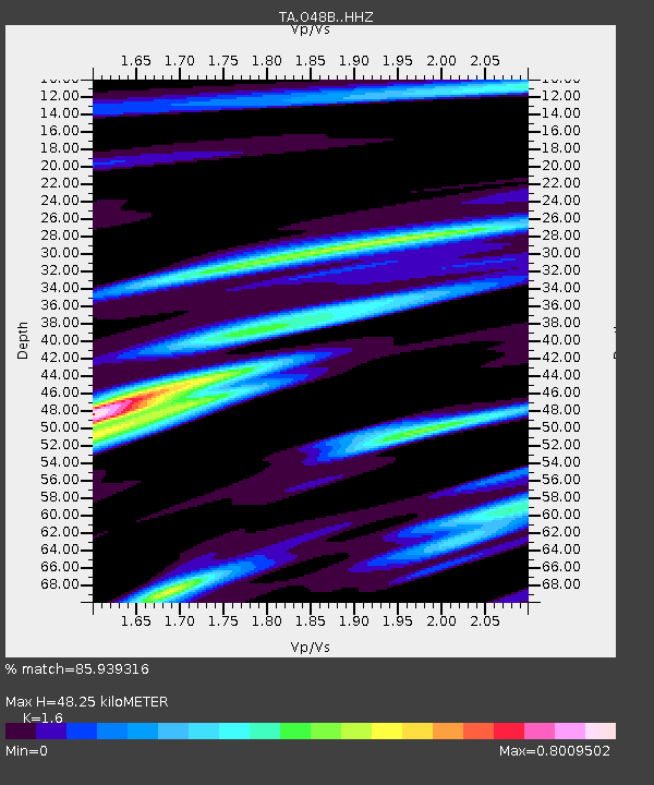
| Estimated Moho Depth: |
48.25 km |
| Estimated Crust Vp/Vs: |
1.60 |
| Assumed Crust Vp: |
6.498 km/s |
| Estimated Crust Vs: |
4.061 km/s |
| Estimated Crust Poisson's Ratio: |
0.18 |
|
| Radial Match: |
85.939316 % |
| Radial Bump: |
343 |
| Transverse Match: |
61.154316 % |
| Transverse Bump: |
400 |
| SOD ConfigId: |
7422571 |
| Insert Time: |
2019-04-22 02:13:09.018 +0000 |
| GWidth: |
2.5 |
| Max Bumps: |
400 |
| Tol: |
0.001 |
|

Signal To Noise
| Channel | StoN | STA | LTA |
| TA:O48B: :HHZ:20160320T23:00:53.94998Z | 4.203163 | 7.762522E-7 | 1.8468288E-7 |
| TA:O48B: :HHN:20160320T23:00:53.94998Z | 3.6953466 | 5.360506E-7 | 1.4506098E-7 |
| TA:O48B: :HHE:20160320T23:00:53.94998Z | 1.3806088 | 3.653046E-7 | 2.6459676E-7 |
| Arrivals |
| Ps | 4.7 SECOND |
| PpPs | 18 SECOND |
| PsPs/PpSs | 23 SECOND |


