You are here: Home > Network List > TA - USArray Transportable Network (new EarthScope stations) Stations List
> Station P52A Corning, OH, USA > Earthquake Result Viewer
P52A Corning, OH, USA - Earthquake Result Viewer
| Earthquake location: |
Near East Coast Of Kamchatka |
| Earthquake latitude/longitude: |
54.3/162.8 |
| Earthquake time(UTC): |
2016/03/20 (080) 22:50:20 GMT |
| Earthquake Depth: |
31 km |
| Earthquake Magnitude: |
6.4 MWC, 6.2 MWB, 6.6 MI |
| Earthquake Catalog/Contributor: |
NEIC PDE/NEIC COMCAT |
|
| Network: |
TA USArray Transportable Network (new EarthScope stations) |
| Station: |
P52A Corning, OH, USA |
| Lat/Lon: |
39.63 N/82.13 W |
| Elevation: |
293 m |
|
| Distance: |
71.1 deg |
| Az: |
47.663 deg |
| Baz: |
325.902 deg |
| Ray Param: |
0.054479294 |
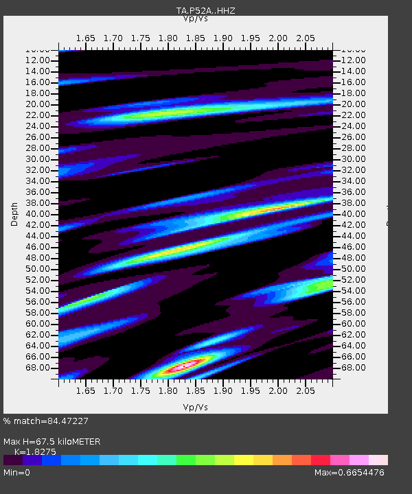
| Estimated Moho Depth: |
67.5 km |
| Estimated Crust Vp/Vs: |
1.83 |
| Assumed Crust Vp: |
6.232 km/s |
| Estimated Crust Vs: |
3.41 km/s |
| Estimated Crust Poisson's Ratio: |
0.29 |
|
| Radial Match: |
84.47227 % |
| Radial Bump: |
351 |
| Transverse Match: |
64.394714 % |
| Transverse Bump: |
400 |
| SOD ConfigId: |
7422571 |
| Insert Time: |
2019-04-22 02:13:13.362 +0000 |
| GWidth: |
2.5 |
| Max Bumps: |
400 |
| Tol: |
0.001 |
|

Signal To Noise
| Channel | StoN | STA | LTA |
| TA:P52A: :HHZ:20160320T23:01:05.170012Z | 3.4763575 | 8.65217E-7 | 2.4888607E-7 |
| TA:P52A: :HHN:20160320T23:01:05.170012Z | 2.265469 | 4.6713694E-7 | 2.0619878E-7 |
| TA:P52A: :HHE:20160320T23:01:05.170012Z | 1.185543 | 2.6369756E-7 | 2.2242767E-7 |
| Arrivals |
| Ps | 9.3 SECOND |
| PpPs | 30 SECOND |
| PsPs/PpSs | 39 SECOND |


