You are here: Home > Network List > TA - USArray Transportable Network (new EarthScope stations) Stations List
> Station T25A Trinidad, CO, USA > Earthquake Result Viewer
T25A Trinidad, CO, USA - Earthquake Result Viewer

| Earthquake location: |
Near East Coast Of Kamchatka |
| Earthquake latitude/longitude: |
54.3/162.8 |
| Earthquake time(UTC): |
2016/03/20 (080) 22:50:20 GMT |
| Earthquake Depth: |
31 km |
| Earthquake Magnitude: |
6.4 MWC, 6.2 MWB, 6.6 MI |
| Earthquake Catalog/Contributor: |
NEIC PDE/NEIC COMCAT |
|
| Network: |
TA USArray Transportable Network (new EarthScope stations) |
| Station: |
T25A Trinidad, CO, USA |
| Lat/Lon: |
37.14 N/104.41 W |
| Elevation: |
2017 m |
|
| Distance: |
62.3 deg |
| Az: |
64.33 deg |
| Baz: |
318.658 deg |
| Ray Param: |
0.060251527 |
| Estimated Moho Depth: |
41.0 km |
| Estimated Crust Vp/Vs: |
1.80 |
| Assumed Crust Vp: |
6.316 km/s |
| Estimated Crust Vs: |
3.518 km/s |
| Estimated Crust Poisson's Ratio: |
0.27 |
|
| Radial Match: |
92.80242 % |
| Radial Bump: |
252 |
| Transverse Match: |
86.58867 % |
| Transverse Bump: |
318 |
| SOD ConfigId: |
7422571 |
| Insert Time: |
2019-04-22 02:13:14.819 +0000 |
| GWidth: |
2.5 |
| Max Bumps: |
400 |
| Tol: |
0.001 |
|
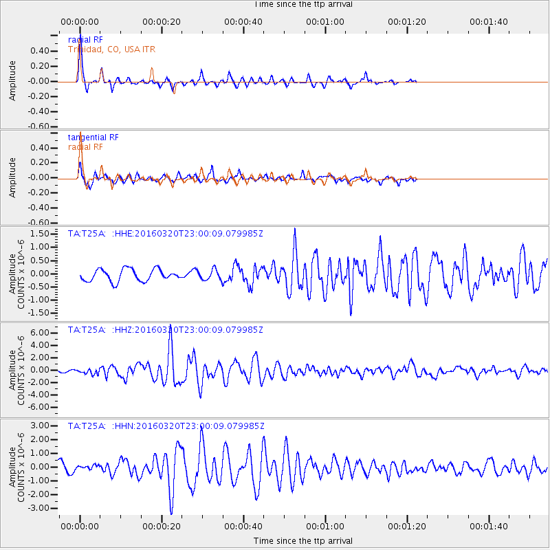
Signal To Noise
| Channel | StoN | STA | LTA |
| TA:T25A: :HHZ:20160320T23:00:09.079985Z | 2.674888 | 3.9331172E-7 | 1.4703858E-7 |
| TA:T25A: :HHN:20160320T23:00:09.079985Z | 0.84646577 | 1.6289712E-7 | 1.9244385E-7 |
| TA:T25A: :HHE:20160320T23:00:09.079985Z | 0.9153094 | 2.0566532E-7 | 2.2469484E-7 |
| Arrivals |
| Ps | 5.4 SECOND |
| PpPs | 17 SECOND |
| PsPs/PpSs | 23 SECOND |


