You are here: Home > Network List > TA - USArray Transportable Network (new EarthScope stations) Stations List
> Station W41B Gary Mavity, Velonia, AR, USA > Earthquake Result Viewer
W41B Gary Mavity, Velonia, AR, USA - Earthquake Result Viewer
| Earthquake location: |
Near East Coast Of Kamchatka |
| Earthquake latitude/longitude: |
54.3/162.8 |
| Earthquake time(UTC): |
2016/03/20 (080) 22:50:20 GMT |
| Earthquake Depth: |
31 km |
| Earthquake Magnitude: |
6.4 MWC, 6.2 MWB, 6.6 MI |
| Earthquake Catalog/Contributor: |
NEIC PDE/NEIC COMCAT |
|
| Network: |
TA USArray Transportable Network (new EarthScope stations) |
| Station: |
W41B Gary Mavity, Velonia, AR, USA |
| Lat/Lon: |
35.17 N/92.25 W |
| Elevation: |
95 m |
|
| Distance: |
70.1 deg |
| Az: |
57.347 deg |
| Baz: |
322.993 deg |
| Ray Param: |
0.055186905 |
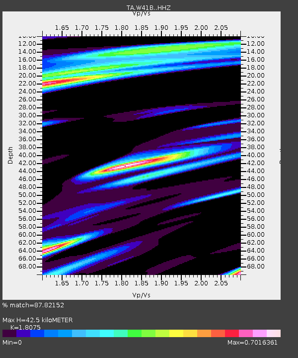
| Estimated Moho Depth: |
42.5 km |
| Estimated Crust Vp/Vs: |
1.81 |
| Assumed Crust Vp: |
6.498 km/s |
| Estimated Crust Vs: |
3.595 km/s |
| Estimated Crust Poisson's Ratio: |
0.28 |
|
| Radial Match: |
87.82152 % |
| Radial Bump: |
383 |
| Transverse Match: |
80.878654 % |
| Transverse Bump: |
375 |
| SOD ConfigId: |
7422571 |
| Insert Time: |
2019-04-22 02:13:19.595 +0000 |
| GWidth: |
2.5 |
| Max Bumps: |
400 |
| Tol: |
0.001 |
|
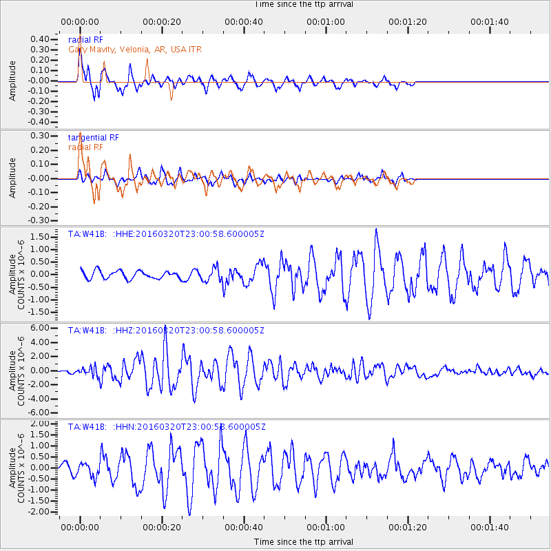
Signal To Noise
| Channel | StoN | STA | LTA |
| TA:W41B: :HHZ:20160320T23:00:58.600005Z | 2.003969 | 6.701461E-7 | 3.3440944E-7 |
| TA:W41B: :HHN:20160320T23:00:58.600005Z | 2.9023957 | 3.1643998E-7 | 1.09027155E-7 |
| TA:W41B: :HHE:20160320T23:00:58.600005Z | 1.8261225 | 2.829146E-7 | 1.5492641E-7 |
| Arrivals |
| Ps | 5.5 SECOND |
| PpPs | 18 SECOND |
| PsPs/PpSs | 23 SECOND |


