You are here: Home > Network List > TD - TransAlta Monitoring Network Stations List
> Station TD011 Z > Earthquake Result Viewer
TD011 Z - Earthquake Result Viewer
| Earthquake location: |
Near East Coast Of Kamchatka |
| Earthquake latitude/longitude: |
54.3/162.8 |
| Earthquake time(UTC): |
2016/03/20 (080) 22:50:20 GMT |
| Earthquake Depth: |
31 km |
| Earthquake Magnitude: |
6.4 MWC, 6.2 MWB, 6.6 MI |
| Earthquake Catalog/Contributor: |
NEIC PDE/NEIC COMCAT |
|
| Network: |
TD TransAlta Monitoring Network |
| Station: |
TD011 Z |
| Lat/Lon: |
52.55 N/115.52 W |
| Elevation: |
1103 m |
|
| Distance: |
46.1 deg |
| Az: |
57.012 deg |
| Baz: |
306.441 deg |
| Ray Param: |
0.07080498 |
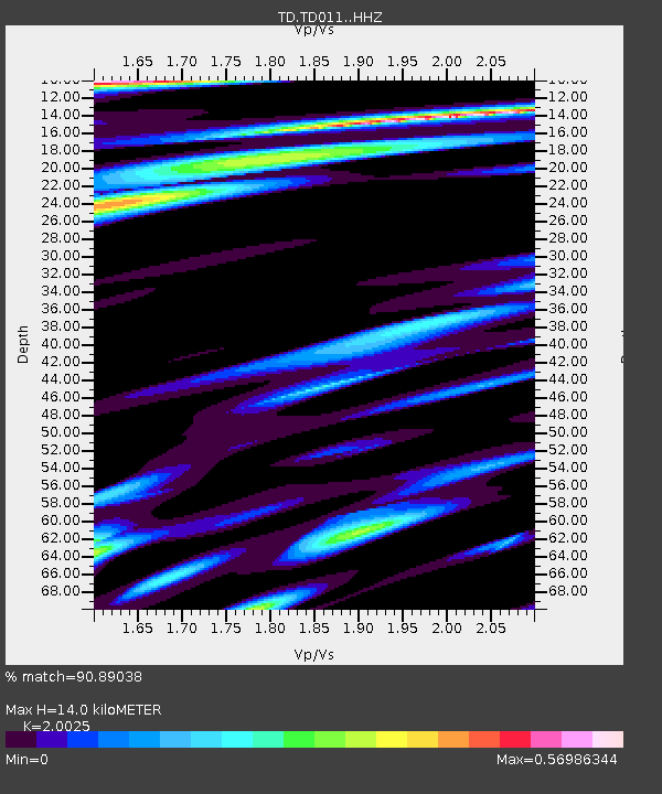
| Estimated Moho Depth: |
14.0 km |
| Estimated Crust Vp/Vs: |
2.00 |
| Assumed Crust Vp: |
6.426 km/s |
| Estimated Crust Vs: |
3.209 km/s |
| Estimated Crust Poisson's Ratio: |
0.33 |
|
| Radial Match: |
90.89038 % |
| Radial Bump: |
400 |
| Transverse Match: |
68.95687 % |
| Transverse Bump: |
400 |
| SOD ConfigId: |
7422571 |
| Insert Time: |
2019-04-22 02:13:33.626 +0000 |
| GWidth: |
2.5 |
| Max Bumps: |
400 |
| Tol: |
0.001 |
|

Signal To Noise
| Channel | StoN | STA | LTA |
| TD:TD011: :HHZ:20160320T22:58:11.119994Z | 4.272802 | 9.557564E-7 | 2.2368376E-7 |
| TD:TD011: :HH1:20160320T22:58:11.119994Z | 2.3327749 | 4.3368507E-7 | 1.8590953E-7 |
| TD:TD011: :HH2:20160320T22:58:11.119994Z | 1.4844816 | 4.1189332E-7 | 2.774661E-7 |
| Arrivals |
| Ps | 2.3 SECOND |
| PpPs | 6.2 SECOND |
| PsPs/PpSs | 8.5 SECOND |


