You are here: Home > Network List > UW - Pacific Northwest Regional Seismic Network Stations List
> Station CCRK Sunnyside, WA, USA > Earthquake Result Viewer
CCRK Sunnyside, WA, USA - Earthquake Result Viewer
| Earthquake location: |
Near East Coast Of Kamchatka |
| Earthquake latitude/longitude: |
54.3/162.8 |
| Earthquake time(UTC): |
2016/03/20 (080) 22:50:20 GMT |
| Earthquake Depth: |
31 km |
| Earthquake Magnitude: |
6.4 MWC, 6.2 MWB, 6.6 MI |
| Earthquake Catalog/Contributor: |
NEIC PDE/NEIC COMCAT |
|
| Network: |
UW Pacific Northwest Regional Seismic Network |
| Station: |
CCRK Sunnyside, WA, USA |
| Lat/Lon: |
46.56 N/119.85 W |
| Elevation: |
561 m |
|
| Distance: |
47.5 deg |
| Az: |
65.887 deg |
| Baz: |
309.225 deg |
| Ray Param: |
0.069869846 |
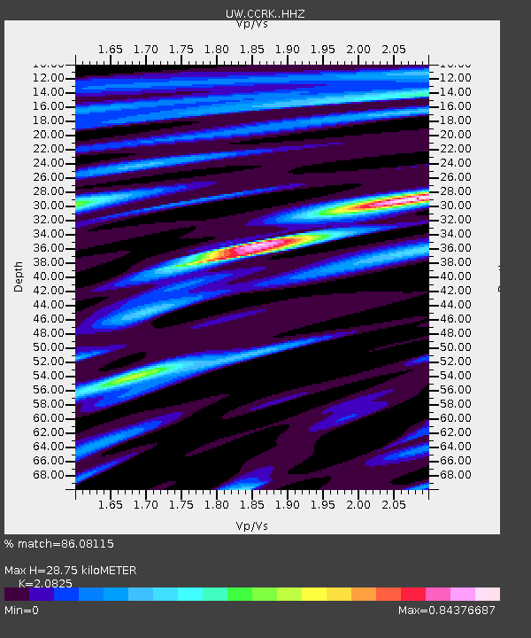
| Estimated Moho Depth: |
28.75 km |
| Estimated Crust Vp/Vs: |
2.08 |
| Assumed Crust Vp: |
6.419 km/s |
| Estimated Crust Vs: |
3.082 km/s |
| Estimated Crust Poisson's Ratio: |
0.35 |
|
| Radial Match: |
86.08115 % |
| Radial Bump: |
392 |
| Transverse Match: |
69.08791 % |
| Transverse Bump: |
400 |
| SOD ConfigId: |
7422571 |
| Insert Time: |
2019-04-22 02:14:06.950 +0000 |
| GWidth: |
2.5 |
| Max Bumps: |
400 |
| Tol: |
0.001 |
|

Signal To Noise
| Channel | StoN | STA | LTA |
| UW:CCRK: :HHZ:20160320T22:58:22.36801Z | 3.8237085 | 1.3080938E-6 | 3.421008E-7 |
| UW:CCRK: :HHN:20160320T22:58:22.36801Z | 1.8689898 | 4.6130367E-7 | 2.4681978E-7 |
| UW:CCRK: :HHE:20160320T22:58:22.36801Z | 2.686937 | 4.812905E-7 | 1.7912234E-7 |
| Arrivals |
| Ps | 5.1 SECOND |
| PpPs | 13 SECOND |
| PsPs/PpSs | 18 SECOND |


