You are here: Home > Network List > UW - Pacific Northwest Regional Seismic Network Stations List
> Station YACT Amboy, WA, USA > Earthquake Result Viewer
YACT Amboy, WA, USA - Earthquake Result Viewer
| Earthquake location: |
Near East Coast Of Kamchatka |
| Earthquake latitude/longitude: |
54.3/162.8 |
| Earthquake time(UTC): |
2016/03/20 (080) 22:50:20 GMT |
| Earthquake Depth: |
31 km |
| Earthquake Magnitude: |
6.4 MWC, 6.2 MWB, 6.6 MI |
| Earthquake Catalog/Contributor: |
NEIC PDE/NEIC COMCAT |
|
| Network: |
UW Pacific Northwest Regional Seismic Network |
| Station: |
YACT Amboy, WA, USA |
| Lat/Lon: |
45.93 N/122.42 W |
| Elevation: |
211 m |
|
| Distance: |
46.5 deg |
| Az: |
68.083 deg |
| Baz: |
308.875 deg |
| Ray Param: |
0.0705206 |
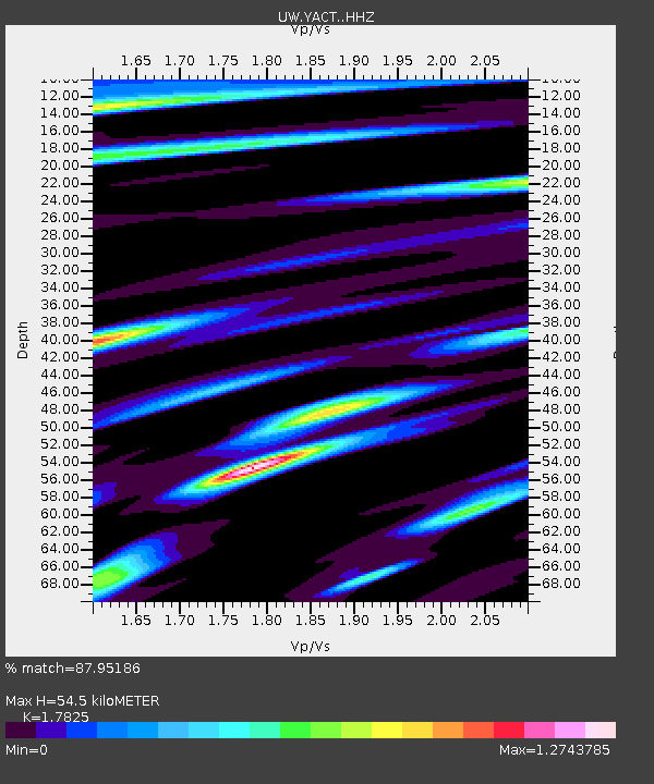
| Estimated Moho Depth: |
54.5 km |
| Estimated Crust Vp/Vs: |
1.78 |
| Assumed Crust Vp: |
6.566 km/s |
| Estimated Crust Vs: |
3.684 km/s |
| Estimated Crust Poisson's Ratio: |
0.27 |
|
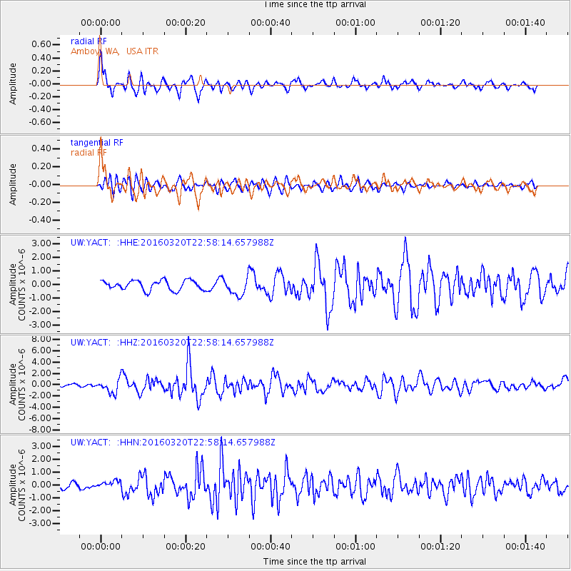
| Radial Match: |
87.95186 % |
| Radial Bump: |
400 |
| Transverse Match: |
66.03215 % |
| Transverse Bump: |
400 |
| SOD ConfigId: |
7422571 |
| Insert Time: |
2019-04-22 02:14:32.002 +0000 |
| GWidth: |
2.5 |
| Max Bumps: |
400 |
| Tol: |
0.001 |
|
Signal To Noise
| Channel | StoN | STA | LTA |
| UW:YACT: :HHZ:20160320T22:58:14.657988Z | 8.105635 | 1.2823695E-6 | 1.5820716E-7 |
| UW:YACT: :HHN:20160320T22:58:14.657988Z | 1.4792161 | 2.7959607E-7 | 1.8901639E-7 |
| UW:YACT: :HHE:20160320T22:58:14.657988Z | 1.9365791 | 6.9222756E-7 | 3.5744864E-7 |
| Arrivals |
| Ps | 6.9 SECOND |
| PpPs | 22 SECOND |
| PsPs/PpSs | 29 SECOND |


