You are here: Home > Network List > XL12 - Hangay Dome, Mongolia Stations List
> Station HV31 HV31 > Earthquake Result Viewer
HV31 HV31 - Earthquake Result Viewer
| Earthquake location: |
Near East Coast Of Kamchatka |
| Earthquake latitude/longitude: |
54.3/162.8 |
| Earthquake time(UTC): |
2016/03/20 (080) 22:50:20 GMT |
| Earthquake Depth: |
31 km |
| Earthquake Magnitude: |
6.4 MWC, 6.2 MWB, 6.6 MI |
| Earthquake Catalog/Contributor: |
NEIC PDE/NEIC COMCAT |
|
| Network: |
XL Hangay Dome, Mongolia |
| Station: |
HV31 HV31 |
| Lat/Lon: |
51.34 N/100.24 E |
| Elevation: |
1693 m |
|
| Distance: |
36.8 deg |
| Az: |
291.719 deg |
| Baz: |
60.152 deg |
| Ray Param: |
0.07641875 |
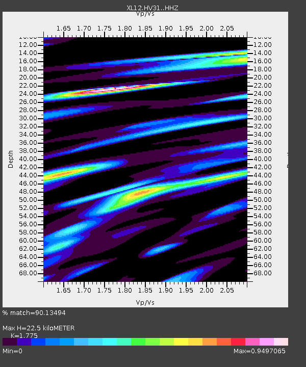
| Estimated Moho Depth: |
22.5 km |
| Estimated Crust Vp/Vs: |
1.77 |
| Assumed Crust Vp: |
6.419 km/s |
| Estimated Crust Vs: |
3.616 km/s |
| Estimated Crust Poisson's Ratio: |
0.27 |
|
| Radial Match: |
90.13494 % |
| Radial Bump: |
400 |
| Transverse Match: |
59.68596 % |
| Transverse Bump: |
400 |
| SOD ConfigId: |
7422571 |
| Insert Time: |
2019-04-22 02:16:10.068 +0000 |
| GWidth: |
2.5 |
| Max Bumps: |
400 |
| Tol: |
0.001 |
|

Signal To Noise
| Channel | StoN | STA | LTA |
| XL:HV31: :HHZ:20160320T22:56:55.339995Z | 24.441818 | 1.5971895E-6 | 6.534659E-8 |
| XL:HV31: :HHN:20160320T22:56:55.339995Z | 7.9864864 | 5.2070806E-7 | 6.519864E-8 |
| XL:HV31: :HHE:20160320T22:56:55.339995Z | 15.300457 | 1.0220513E-6 | 6.6798734E-8 |
| Arrivals |
| Ps | 2.9 SECOND |
| PpPs | 9.0 SECOND |
| PsPs/PpSs | 12 SECOND |


