You are here: Home > Network List > US - United States National Seismic Network Stations List
> Station MNTX Cornudas Mountains, Texas, USA > Earthquake Result Viewer
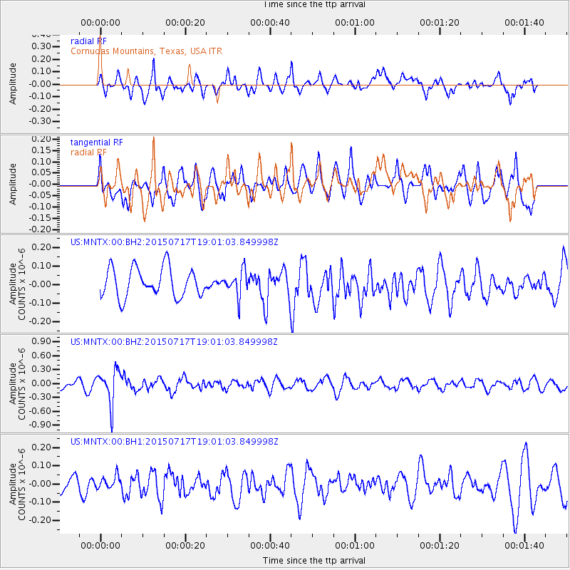
MNTX Cornudas Mountains, Texas, USA - Earthquake Result Viewer
*The percent match for this event was below the threshold and hence no stack was calculated.
| Earthquake location: |
Fiji Islands Region |
| Earthquake latitude/longitude: |
-18.1/-178.2 |
| Earthquake time(UTC): |
2015/07/17 (198) 18:49:53 GMT |
| Earthquake Depth: |
537 km |
| Earthquake Magnitude: |
5.8 MWW, 5.8 MWC, 5.9 MWB, 5.9 MWC |
| Earthquake Catalog/Contributor: |
NEIC PDE/NEIC COMCAT |
|
| Network: |
US United States National Seismic Network |
| Station: |
MNTX Cornudas Mountains, Texas, USA |
| Lat/Lon: |
31.70 N/105.38 W |
| Elevation: |
404 m |
|
| Distance: |
85.5 deg |
| Az: |
54.768 deg |
| Baz: |
245.697 deg |
| Ray Param: |
$rayparam |
*The percent match for this event was below the threshold and hence was not used in the summary stack. |
|
| Radial Match: |
63.537617 % |
| Radial Bump: |
400 |
| Transverse Match: |
59.527477 % |
| Transverse Bump: |
400 |
| SOD ConfigId: |
1085051 |
| Insert Time: |
2015-07-31 19:02:54.247 +0000 |
| GWidth: |
2.5 |
| Max Bumps: |
400 |
| Tol: |
0.001 |
|
Signal To Noise
| Channel | StoN | STA | LTA |
| US:MNTX:00:BHZ:20150717T19:01:03.849998Z | 3.5903637 | 3.709857E-7 | 1.0332817E-7 |
| US:MNTX:00:BH1:20150717T19:01:03.849998Z | 0.38368562 | 3.687541E-8 | 9.6108394E-8 |
| US:MNTX:00:BH2:20150717T19:01:03.849998Z | 0.8754867 | 6.8987966E-8 | 7.8799566E-8 |
| Arrivals |
| Ps | |
| PpPs | |
| PsPs/PpSs | |


