You are here: Home > Network List > CI - Caltech Regional Seismic Network Stations List
> Station BAR Barrett, Tecate, CA, USA > Earthquake Result Viewer
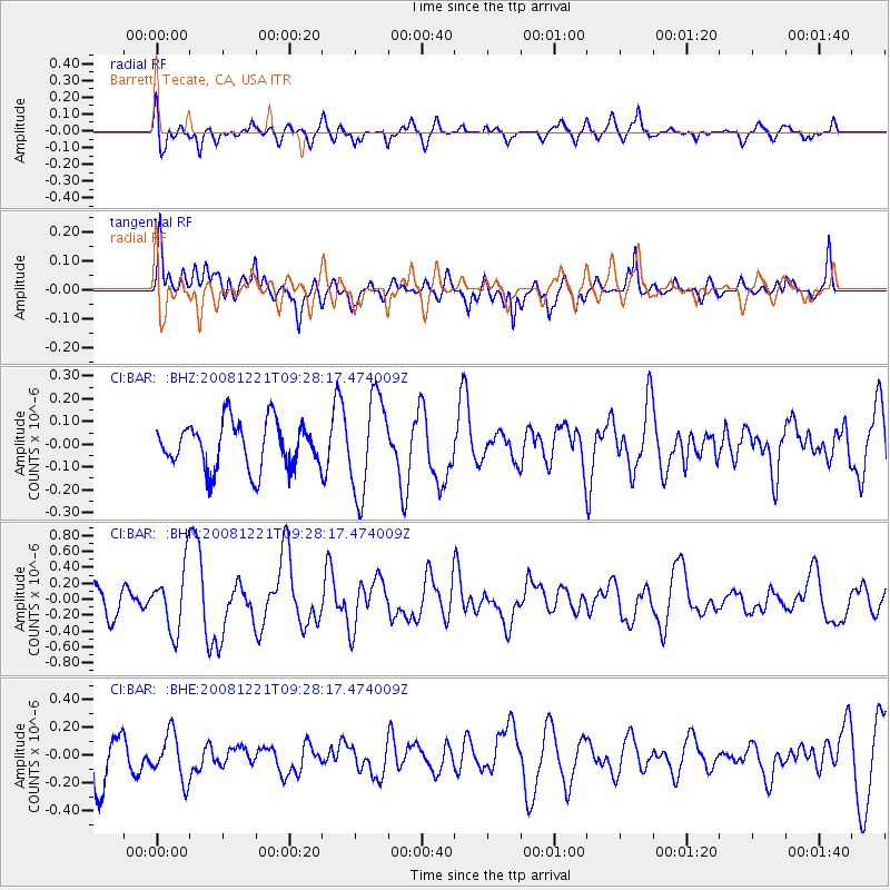
BAR Barrett, Tecate, CA, USA - Earthquake Result Viewer
*The percent match for this event was below the threshold and hence no stack was calculated.
| Earthquake location: |
Off East Coast Of Honshu, Japan |
| Earthquake latitude/longitude: |
36.5/142.3 |
| Earthquake time(UTC): |
2008/12/21 (356) 09:16:44 GMT |
| Earthquake Depth: |
13 km |
| Earthquake Magnitude: |
5.6 MB, 5.7 MS, 5.9 MW, 5.9 MW |
| Earthquake Catalog/Contributor: |
WHDF/NEIC |
|
| Network: |
CI Caltech Regional Seismic Network |
| Station: |
BAR Barrett, Tecate, CA, USA |
| Lat/Lon: |
32.68 N/116.67 W |
| Elevation: |
521 m |
|
| Distance: |
79.1 deg |
| Az: |
57.457 deg |
| Baz: |
306.39 deg |
| Ray Param: |
$rayparam |
*The percent match for this event was below the threshold and hence was not used in the summary stack. |
|
| Radial Match: |
55.918606 % |
| Radial Bump: |
400 |
| Transverse Match: |
56.520786 % |
| Transverse Bump: |
400 |
| SOD ConfigId: |
2658 |
| Insert Time: |
2010-02-26 00:11:13.878 +0000 |
| GWidth: |
2.5 |
| Max Bumps: |
400 |
| Tol: |
0.001 |
|
Signal To Noise
| Channel | StoN | STA | LTA |
| CI:BAR: :BHN:20081221T09:28:17.474009Z | 2.3579843 | 3.9460966E-7 | 1.6735041E-7 |
| CI:BAR: :BHE:20081221T09:28:17.474009Z | 0.96126246 | 1.6740762E-7 | 1.7415391E-7 |
| CI:BAR: :BHZ:20081221T09:28:17.474009Z | 2.0822003 | 2.1098634E-7 | 1.0132855E-7 |
| Arrivals |
| Ps | |
| PpPs | |
| PsPs/PpSs | |


