You are here: Home > Network List > TA - USArray Transportable Network (new EarthScope stations) Stations List
> Station BGNE Belgrade, NE, USA > Earthquake Result Viewer
BGNE Belgrade, NE, USA - Earthquake Result Viewer
| Earthquake location: |
Fox Islands, Aleutian Islands |
| Earthquake latitude/longitude: |
52.2/-168.7 |
| Earthquake time(UTC): |
2016/03/27 (087) 18:01:30 GMT |
| Earthquake Depth: |
16 km |
| Earthquake Magnitude: |
5.7 MWB |
| Earthquake Catalog/Contributor: |
NEIC PDE/NEIC COMCAT |
|
| Network: |
TA USArray Transportable Network (new EarthScope stations) |
| Station: |
BGNE Belgrade, NE, USA |
| Lat/Lon: |
41.41 N/98.15 W |
| Elevation: |
573 m |
|
| Distance: |
47.7 deg |
| Az: |
73.609 deg |
| Baz: |
308.261 deg |
| Ray Param: |
0.06981367 |
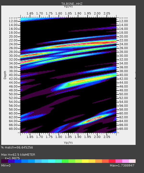
| Estimated Moho Depth: |
62.5 km |
| Estimated Crust Vp/Vs: |
1.99 |
| Assumed Crust Vp: |
6.53 km/s |
| Estimated Crust Vs: |
3.286 km/s |
| Estimated Crust Poisson's Ratio: |
0.33 |
|
| Radial Match: |
86.645256 % |
| Radial Bump: |
400 |
| Transverse Match: |
73.75751 % |
| Transverse Bump: |
400 |
| SOD ConfigId: |
7422571 |
| Insert Time: |
2019-04-22 02:34:12.176 +0000 |
| GWidth: |
2.5 |
| Max Bumps: |
400 |
| Tol: |
0.001 |
|

Signal To Noise
| Channel | StoN | STA | LTA |
| TA:BGNE: :HHZ:20160327T18:09:35.349996Z | 4.4061527 | 4.110556E-7 | 9.329128E-8 |
| TA:BGNE: :HHN:20160327T18:09:35.349996Z | 1.4361258 | 3.3493916E-7 | 2.3322411E-7 |
| TA:BGNE: :HHE:20160327T18:09:35.349996Z | 1.9073812 | 3.7056384E-7 | 1.9427885E-7 |
| Arrivals |
| Ps | 10.0 SECOND |
| PpPs | 27 SECOND |
| PsPs/PpSs | 37 SECOND |


