You are here: Home > Network List > TA - USArray Transportable Network (new EarthScope stations) Stations List
> Station K22A Casper, WY, USA > Earthquake Result Viewer
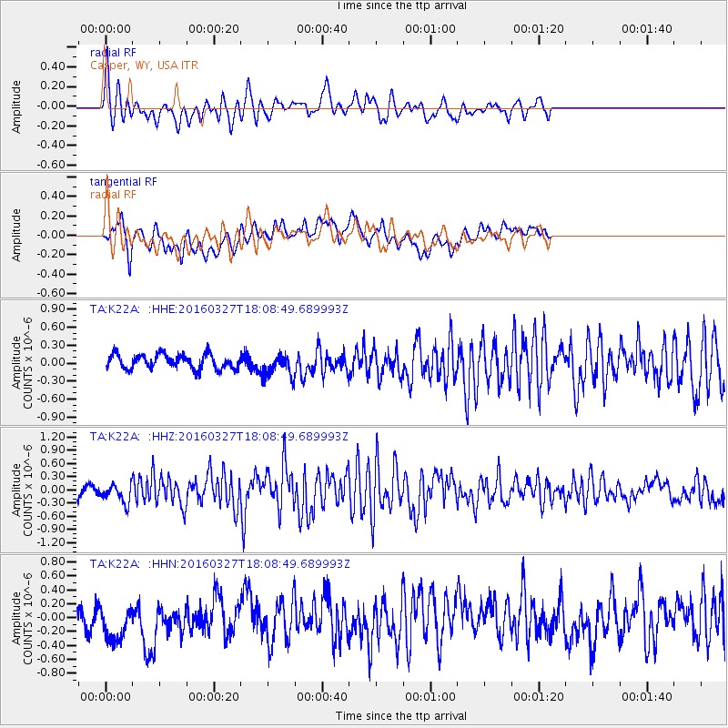
K22A Casper, WY, USA - Earthquake Result Viewer
*The percent match for this event was below the threshold and hence no stack was calculated.
| Earthquake location: |
Fox Islands, Aleutian Islands |
| Earthquake latitude/longitude: |
52.2/-168.7 |
| Earthquake time(UTC): |
2016/03/27 (087) 18:01:30 GMT |
| Earthquake Depth: |
16 km |
| Earthquake Magnitude: |
5.7 MWB |
| Earthquake Catalog/Contributor: |
NEIC PDE/NEIC COMCAT |
|
| Network: |
TA USArray Transportable Network (new EarthScope stations) |
| Station: |
K22A Casper, WY, USA |
| Lat/Lon: |
42.65 N/106.52 W |
| Elevation: |
1686 m |
|
| Distance: |
42.0 deg |
| Az: |
77.507 deg |
| Baz: |
305.439 deg |
| Ray Param: |
$rayparam |
*The percent match for this event was below the threshold and hence was not used in the summary stack. |
|
| Radial Match: |
76.0515 % |
| Radial Bump: |
400 |
| Transverse Match: |
61.64089 % |
| Transverse Bump: |
400 |
| SOD ConfigId: |
7422571 |
| Insert Time: |
2019-04-22 02:34:16.583 +0000 |
| GWidth: |
2.5 |
| Max Bumps: |
400 |
| Tol: |
0.001 |
|
Signal To Noise
| Channel | StoN | STA | LTA |
| TA:K22A: :HHZ:20160327T18:08:49.689993Z | 2.5739093 | 2.1998079E-7 | 8.5465636E-8 |
| TA:K22A: :HHN:20160327T18:08:49.689993Z | 1.9301885 | 3.2309782E-7 | 1.6739185E-7 |
| TA:K22A: :HHE:20160327T18:08:49.689993Z | 1.570457 | 1.8732261E-7 | 1.1927905E-7 |
| Arrivals |
| Ps | |
| PpPs | |
| PsPs/PpSs | |


