You are here: Home > Network List > TA - USArray Transportable Network (new EarthScope stations) Stations List
> Station SUSD Miller, SD, USA > Earthquake Result Viewer
SUSD Miller, SD, USA - Earthquake Result Viewer
| Earthquake location: |
Fox Islands, Aleutian Islands |
| Earthquake latitude/longitude: |
52.2/-168.7 |
| Earthquake time(UTC): |
2016/03/27 (087) 18:01:30 GMT |
| Earthquake Depth: |
16 km |
| Earthquake Magnitude: |
5.7 MWB |
| Earthquake Catalog/Contributor: |
NEIC PDE/NEIC COMCAT |
|
| Network: |
TA USArray Transportable Network (new EarthScope stations) |
| Station: |
SUSD Miller, SD, USA |
| Lat/Lon: |
44.44 N/98.96 W |
| Elevation: |
520 m |
|
| Distance: |
45.4 deg |
| Az: |
70.763 deg |
| Baz: |
305.756 deg |
| Ray Param: |
0.07129233 |
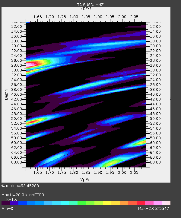
| Estimated Moho Depth: |
28.0 km |
| Estimated Crust Vp/Vs: |
1.60 |
| Assumed Crust Vp: |
6.53 km/s |
| Estimated Crust Vs: |
4.082 km/s |
| Estimated Crust Poisson's Ratio: |
0.18 |
|
| Radial Match: |
93.45283 % |
| Radial Bump: |
376 |
| Transverse Match: |
84.74294 % |
| Transverse Bump: |
400 |
| SOD ConfigId: |
7422571 |
| Insert Time: |
2019-04-22 02:34:30.604 +0000 |
| GWidth: |
2.5 |
| Max Bumps: |
400 |
| Tol: |
0.001 |
|

Signal To Noise
| Channel | StoN | STA | LTA |
| TA:SUSD: :HHZ:20160327T18:09:17.349996Z | 5.386123 | 5.0947284E-7 | 9.458991E-8 |
| TA:SUSD: :HHN:20160327T18:09:17.349996Z | 1.7150055 | 3.056973E-7 | 1.7824858E-7 |
| TA:SUSD: :HHE:20160327T18:09:17.349996Z | 2.9807687 | 5.489131E-7 | 1.8415153E-7 |
| Arrivals |
| Ps | 2.8 SECOND |
| PpPs | 10 SECOND |
| PsPs/PpSs | 13 SECOND |


