You are here: Home > Network List > CI - Caltech Regional Seismic Network Stations List
> Station BAR Barrett, Tecate, CA, USA > Earthquake Result Viewer
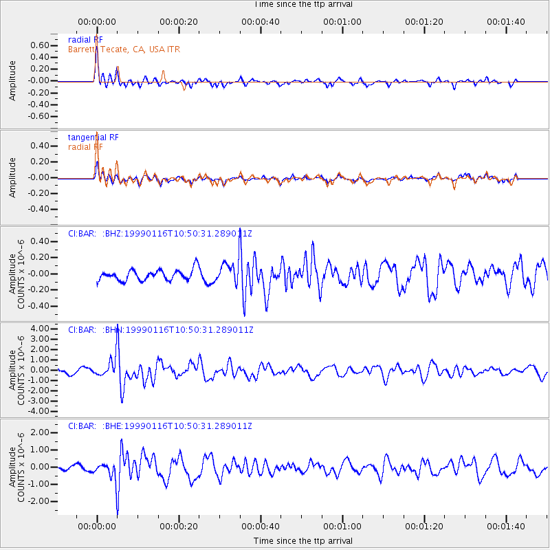
BAR Barrett, Tecate, CA, USA - Earthquake Result Viewer
*The percent match for this event was below the threshold and hence no stack was calculated.
| Earthquake location: |
Gulf Of Alaska |
| Earthquake latitude/longitude: |
56.2/-147.4 |
| Earthquake time(UTC): |
1999/01/16 (016) 10:44:39 GMT |
| Earthquake Depth: |
21 km |
| Earthquake Magnitude: |
5.9 MB, 5.7 MS, 6.0 MW, 6.0 ME |
| Earthquake Catalog/Contributor: |
WHDF/NEIC |
|
| Network: |
CI Caltech Regional Seismic Network |
| Station: |
BAR Barrett, Tecate, CA, USA |
| Lat/Lon: |
32.68 N/116.67 W |
| Elevation: |
521 m |
|
| Distance: |
31.7 deg |
| Az: |
124.927 deg |
| Baz: |
327.121 deg |
| Ray Param: |
$rayparam |
*The percent match for this event was below the threshold and hence was not used in the summary stack. |
|
| Radial Match: |
72.49651 % |
| Radial Bump: |
378 |
| Transverse Match: |
69.43717 % |
| Transverse Bump: |
400 |
| SOD ConfigId: |
4480 |
| Insert Time: |
2010-02-26 00:11:19.779 +0000 |
| GWidth: |
2.5 |
| Max Bumps: |
400 |
| Tol: |
0.001 |
|
Signal To Noise
| Channel | StoN | STA | LTA |
| CI:BAR: :BHN:19990116T10:50:31.289011Z | 5.0415273 | 1.031301E-6 | 2.0456126E-7 |
| CI:BAR: :BHE:19990116T10:50:31.289011Z | 3.910358 | 5.4634666E-7 | 1.3971781E-7 |
| CI:BAR: :BHZ:19990116T10:50:31.289011Z | 2.182616 | 1.4312123E-7 | 6.5573246E-8 |
| Arrivals |
| Ps | |
| PpPs | |
| PsPs/PpSs | |


