You are here: Home > Network List > TA - USArray Transportable Network (new EarthScope stations) Stations List
> Station T25A Trinidad, CO, USA > Earthquake Result Viewer
T25A Trinidad, CO, USA - Earthquake Result Viewer
| Earthquake location: |
Fox Islands, Aleutian Islands |
| Earthquake latitude/longitude: |
52.2/-168.7 |
| Earthquake time(UTC): |
2016/03/27 (087) 18:01:30 GMT |
| Earthquake Depth: |
16 km |
| Earthquake Magnitude: |
5.7 MWB |
| Earthquake Catalog/Contributor: |
NEIC PDE/NEIC COMCAT |
|
| Network: |
TA USArray Transportable Network (new EarthScope stations) |
| Station: |
T25A Trinidad, CO, USA |
| Lat/Lon: |
37.14 N/104.41 W |
| Elevation: |
2017 m |
|
| Distance: |
46.6 deg |
| Az: |
82.304 deg |
| Baz: |
310.228 deg |
| Ray Param: |
0.070517235 |
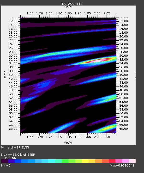
| Estimated Moho Depth: |
33.0 km |
| Estimated Crust Vp/Vs: |
1.99 |
| Assumed Crust Vp: |
6.316 km/s |
| Estimated Crust Vs: |
3.174 km/s |
| Estimated Crust Poisson's Ratio: |
0.33 |
|
| Radial Match: |
87.2155 % |
| Radial Bump: |
385 |
| Transverse Match: |
73.64461 % |
| Transverse Bump: |
372 |
| SOD ConfigId: |
7422571 |
| Insert Time: |
2019-04-22 02:34:31.289 +0000 |
| GWidth: |
2.5 |
| Max Bumps: |
400 |
| Tol: |
0.001 |
|

Signal To Noise
| Channel | StoN | STA | LTA |
| TA:T25A: :HHZ:20160327T18:09:26.969991Z | 2.871504 | 2.0551954E-7 | 7.157209E-8 |
| TA:T25A: :HHN:20160327T18:09:26.969991Z | 1.205407 | 9.678234E-8 | 8.029017E-8 |
| TA:T25A: :HHE:20160327T18:09:26.969991Z | 0.5767025 | 5.33384E-8 | 9.24886E-8 |
| Arrivals |
| Ps | 5.5 SECOND |
| PpPs | 15 SECOND |
| PsPs/PpSs | 20 SECOND |


