You are here: Home > Network List > TA - USArray Transportable Network (new EarthScope stations) Stations List
> Station Z41A Richland Creek Farm, El Dorado, AR, USA > Earthquake Result Viewer
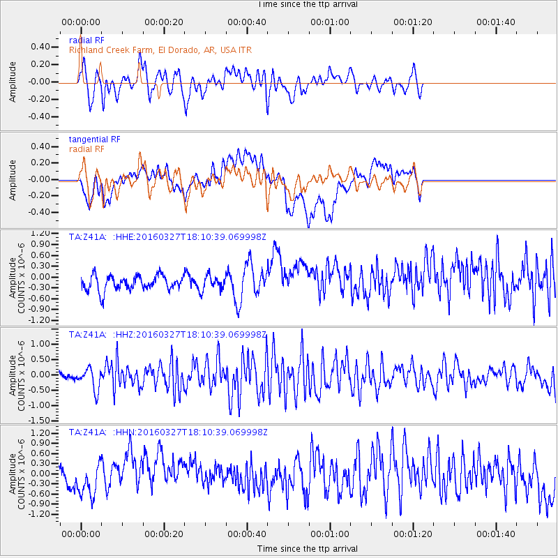
Z41A Richland Creek Farm, El Dorado, AR, USA - Earthquake Result Viewer
*The percent match for this event was below the threshold and hence no stack was calculated.
| Earthquake location: |
Fox Islands, Aleutian Islands |
| Earthquake latitude/longitude: |
52.2/-168.7 |
| Earthquake time(UTC): |
2016/03/27 (087) 18:01:30 GMT |
| Earthquake Depth: |
16 km |
| Earthquake Magnitude: |
5.7 MWB |
| Earthquake Catalog/Contributor: |
NEIC PDE/NEIC COMCAT |
|
| Network: |
TA USArray Transportable Network (new EarthScope stations) |
| Station: |
Z41A Richland Creek Farm, El Dorado, AR, USA |
| Lat/Lon: |
33.26 N/92.80 W |
| Elevation: |
62 m |
|
| Distance: |
56.3 deg |
| Az: |
77.808 deg |
| Baz: |
314.095 deg |
| Ray Param: |
$rayparam |
*The percent match for this event was below the threshold and hence was not used in the summary stack. |
|
| Radial Match: |
60.212383 % |
| Radial Bump: |
400 |
| Transverse Match: |
41.27512 % |
| Transverse Bump: |
400 |
| SOD ConfigId: |
7422571 |
| Insert Time: |
2019-04-22 02:34:36.261 +0000 |
| GWidth: |
2.5 |
| Max Bumps: |
400 |
| Tol: |
0.001 |
|
Signal To Noise
| Channel | StoN | STA | LTA |
| TA:Z41A: :HHZ:20160327T18:10:39.069998Z | 2.6739438 | 3.6296169E-7 | 1.357402E-7 |
| TA:Z41A: :HHN:20160327T18:10:39.069998Z | 1.5663555 | 4.1982648E-7 | 2.6802758E-7 |
| TA:Z41A: :HHE:20160327T18:10:39.069998Z | 0.85895276 | 1.7717565E-7 | 2.0626939E-7 |
| Arrivals |
| Ps | |
| PpPs | |
| PsPs/PpSs | |


