You are here: Home > Network List > CI - Caltech Regional Seismic Network Stations List
> Station MPM Manuel Prospect Mine, California, USA > Earthquake Result Viewer
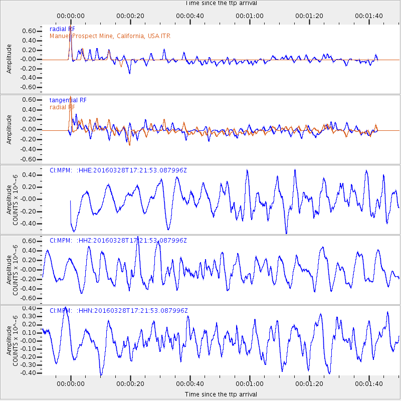
MPM Manuel Prospect Mine, California, USA - Earthquake Result Viewer
*The percent match for this event was below the threshold and hence no stack was calculated.
| Earthquake location: |
Fox Islands, Aleutian Islands |
| Earthquake latitude/longitude: |
52.3/-168.7 |
| Earthquake time(UTC): |
2016/03/28 (088) 17:14:55 GMT |
| Earthquake Depth: |
10 km |
| Earthquake Magnitude: |
5.5 MB, 5.6 MWC, 5.6 MWB |
| Earthquake Catalog/Contributor: |
NEIC PDE/NEIC COMCAT |
|
| Network: |
CI Caltech Regional Seismic Network |
| Station: |
MPM Manuel Prospect Mine, California, USA |
| Lat/Lon: |
36.06 N/117.49 W |
| Elevation: |
185 m |
|
| Distance: |
39.3 deg |
| Az: |
93.709 deg |
| Baz: |
310.87 deg |
| Ray Param: |
$rayparam |
*The percent match for this event was below the threshold and hence was not used in the summary stack. |
|
| Radial Match: |
61.202534 % |
| Radial Bump: |
400 |
| Transverse Match: |
63.745598 % |
| Transverse Bump: |
400 |
| SOD ConfigId: |
7422571 |
| Insert Time: |
2019-04-22 02:43:32.735 +0000 |
| GWidth: |
2.5 |
| Max Bumps: |
400 |
| Tol: |
0.001 |
|
Signal To Noise
| Channel | StoN | STA | LTA |
| CI:MPM: :HHZ:20160328T17:21:53.087996Z | 1.4595015 | 2.650534E-7 | 1.8160542E-7 |
| CI:MPM: :HHN:20160328T17:21:53.087996Z | 1.2397976 | 1.7184016E-7 | 1.386034E-7 |
| CI:MPM: :HHE:20160328T17:21:53.087996Z | 1.5549096 | 2.9350278E-7 | 1.8875875E-7 |
| Arrivals |
| Ps | |
| PpPs | |
| PsPs/PpSs | |


