You are here: Home > Network List > AV - Alaska Volcano Observatory Stations List
> Station SPCN Ckakachatna North Broadband, Mount Spurr, Alaska > Earthquake Result Viewer
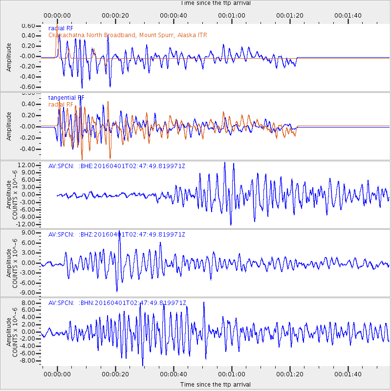
SPCN Ckakachatna North Broadband, Mount Spurr, Alaska - Earthquake Result Viewer
*The percent match for this event was below the threshold and hence no stack was calculated.
| Earthquake location: |
Near S. Coast Of Western Honshu |
| Earthquake latitude/longitude: |
33.4/136.4 |
| Earthquake time(UTC): |
2016/04/01 (092) 02:39:07 GMT |
| Earthquake Depth: |
10 km |
| Earthquake Magnitude: |
6.0 MWP |
| Earthquake Catalog/Contributor: |
NEIC PDE/NEIC COMCAT |
|
| Network: |
AV Alaska Volcano Observatory |
| Station: |
SPCN Ckakachatna North Broadband, Mount Spurr, Alaska |
| Lat/Lon: |
61.22 N/152.19 W |
| Elevation: |
735 m |
|
| Distance: |
52.5 deg |
| Az: |
35.295 deg |
| Baz: |
272.265 deg |
| Ray Param: |
$rayparam |
*The percent match for this event was below the threshold and hence was not used in the summary stack. |
|
| Radial Match: |
91.63083 % |
| Radial Bump: |
335 |
| Transverse Match: |
86.35731 % |
| Transverse Bump: |
400 |
| SOD ConfigId: |
7422571 |
| Insert Time: |
2019-04-22 03:02:05.336 +0000 |
| GWidth: |
2.5 |
| Max Bumps: |
400 |
| Tol: |
0.001 |
|
Signal To Noise
| Channel | StoN | STA | LTA |
| AV:SPCN: :BHZ:20160401T02:47:49.819971Z | 4.989131 | 1.736686E-6 | 3.480939E-7 |
| AV:SPCN: :BHN:20160401T02:47:49.819971Z | 2.1165206 | 1.030791E-6 | 4.870215E-7 |
| AV:SPCN: :BHE:20160401T02:47:49.819971Z | 1.5560151 | 8.8822236E-7 | 5.7083145E-7 |
| Arrivals |
| Ps | |
| PpPs | |
| PsPs/PpSs | |


