You are here: Home > Network List > TA - USArray Transportable Network (new EarthScope stations) Stations List
> Station 121A Cookes Peak, Deming, NM, USA > Earthquake Result Viewer
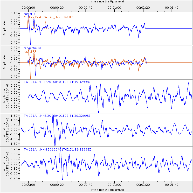
121A Cookes Peak, Deming, NM, USA - Earthquake Result Viewer
*The percent match for this event was below the threshold and hence no stack was calculated.
| Earthquake location: |
Near S. Coast Of Western Honshu |
| Earthquake latitude/longitude: |
33.4/136.4 |
| Earthquake time(UTC): |
2016/04/01 (092) 02:39:07 GMT |
| Earthquake Depth: |
10 km |
| Earthquake Magnitude: |
6.0 MWP |
| Earthquake Catalog/Contributor: |
NEIC PDE/NEIC COMCAT |
|
| Network: |
TA USArray Transportable Network (new EarthScope stations) |
| Station: |
121A Cookes Peak, Deming, NM, USA |
| Lat/Lon: |
32.53 N/107.79 W |
| Elevation: |
1652 m |
|
| Distance: |
90.8 deg |
| Az: |
49.516 deg |
| Baz: |
311.11 deg |
| Ray Param: |
$rayparam |
*The percent match for this event was below the threshold and hence was not used in the summary stack. |
|
| Radial Match: |
77.18026 % |
| Radial Bump: |
334 |
| Transverse Match: |
78.30136 % |
| Transverse Bump: |
400 |
| SOD ConfigId: |
7422571 |
| Insert Time: |
2019-04-22 03:07:34.974 +0000 |
| GWidth: |
2.5 |
| Max Bumps: |
400 |
| Tol: |
0.001 |
|
Signal To Noise
| Channel | StoN | STA | LTA |
| TA:121A: :HHZ:20160401T02:51:39.32998Z | 2.4353995 | 3.4579404E-7 | 1.4198656E-7 |
| TA:121A: :HHN:20160401T02:51:39.32998Z | 0.63921064 | 9.800906E-8 | 1.5332827E-7 |
| TA:121A: :HHE:20160401T02:51:39.32998Z | 0.92822796 | 1.5153898E-7 | 1.6325622E-7 |
| Arrivals |
| Ps | |
| PpPs | |
| PsPs/PpSs | |


