You are here: Home > Network List > TA - USArray Transportable Network (new EarthScope stations) Stations List
> Station MDND Maddock, ND, USA > Earthquake Result Viewer
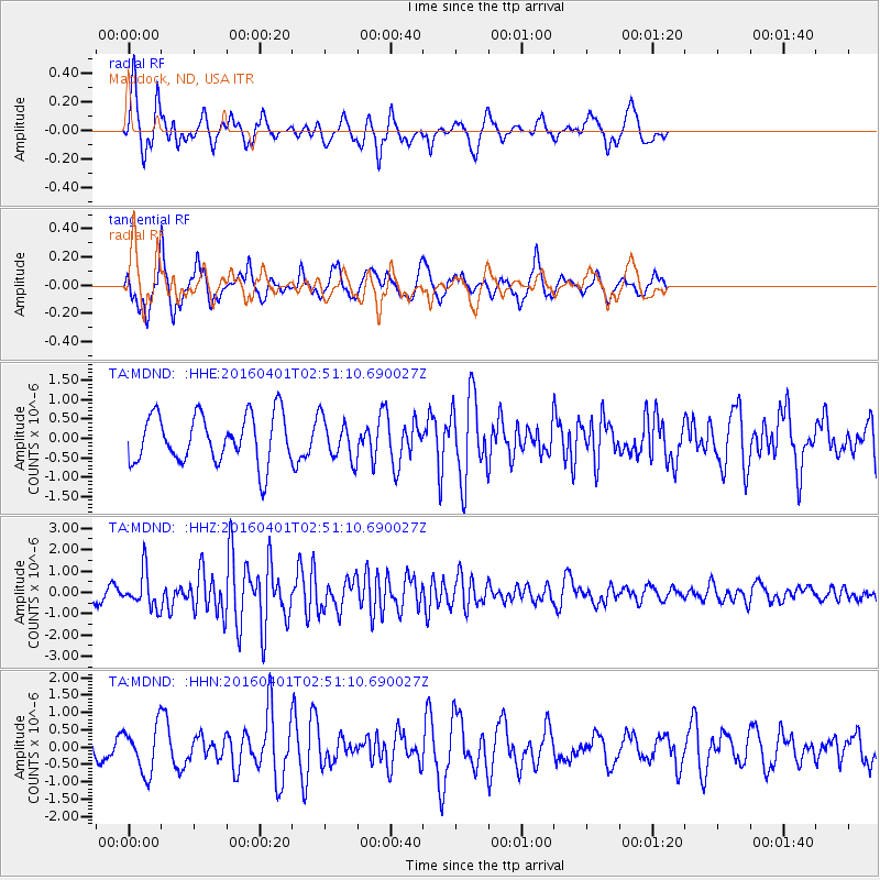
MDND Maddock, ND, USA - Earthquake Result Viewer
*The percent match for this event was below the threshold and hence no stack was calculated.
| Earthquake location: |
Near S. Coast Of Western Honshu |
| Earthquake latitude/longitude: |
33.4/136.4 |
| Earthquake time(UTC): |
2016/04/01 (092) 02:39:07 GMT |
| Earthquake Depth: |
10 km |
| Earthquake Magnitude: |
6.0 MWP |
| Earthquake Catalog/Contributor: |
NEIC PDE/NEIC COMCAT |
|
| Network: |
TA USArray Transportable Network (new EarthScope stations) |
| Station: |
MDND Maddock, ND, USA |
| Lat/Lon: |
47.85 N/99.60 W |
| Elevation: |
479 m |
|
| Distance: |
84.9 deg |
| Az: |
34.11 deg |
| Baz: |
315.84 deg |
| Ray Param: |
$rayparam |
*The percent match for this event was below the threshold and hence was not used in the summary stack. |
|
| Radial Match: |
68.119415 % |
| Radial Bump: |
350 |
| Transverse Match: |
74.4591 % |
| Transverse Bump: |
369 |
| SOD ConfigId: |
7422571 |
| Insert Time: |
2019-04-22 03:08:10.095 +0000 |
| GWidth: |
2.5 |
| Max Bumps: |
400 |
| Tol: |
0.001 |
|
Signal To Noise
| Channel | StoN | STA | LTA |
| TA:MDND: :HHZ:20160401T02:51:10.690027Z | 2.899027 | 8.316823E-7 | 2.8688325E-7 |
| TA:MDND: :HHN:20160401T02:51:10.690027Z | 1.5924138 | 6.644863E-7 | 4.1728245E-7 |
| TA:MDND: :HHE:20160401T02:51:10.690027Z | 0.8419105 | 5.2565764E-7 | 6.243628E-7 |
| Arrivals |
| Ps | |
| PpPs | |
| PsPs/PpSs | |


