You are here: Home > Network List > TA - USArray Transportable Network (new EarthScope stations) Stations List
> Station M53A WI Miller and Sons, Farmdale, OH, USA > Earthquake Result Viewer
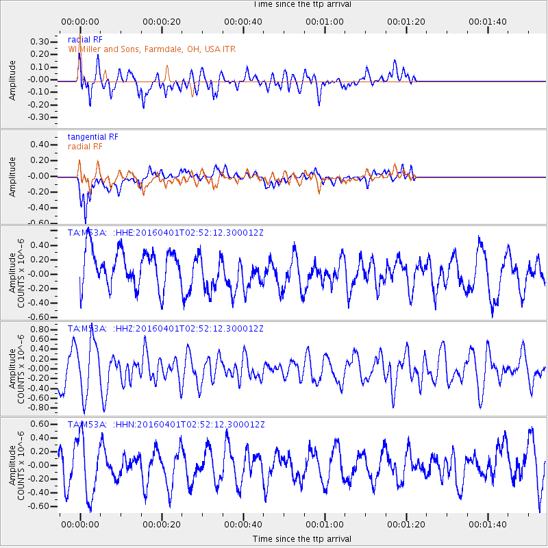
M53A WI Miller and Sons, Farmdale, OH, USA - Earthquake Result Viewer
*The percent match for this event was below the threshold and hence no stack was calculated.
| Earthquake location: |
Near S. Coast Of Western Honshu |
| Earthquake latitude/longitude: |
33.4/136.4 |
| Earthquake time(UTC): |
2016/04/01 (092) 02:39:07 GMT |
| Earthquake Depth: |
10 km |
| Earthquake Magnitude: |
6.0 MWP |
| Earthquake Catalog/Contributor: |
NEIC PDE/NEIC COMCAT |
|
| Network: |
TA USArray Transportable Network (new EarthScope stations) |
| Station: |
M53A WI Miller and Sons, Farmdale, OH, USA |
| Lat/Lon: |
41.44 N/80.68 W |
| Elevation: |
334 m |
|
| Distance: |
98.1 deg |
| Az: |
27.256 deg |
| Baz: |
329.356 deg |
| Ray Param: |
$rayparam |
*The percent match for this event was below the threshold and hence was not used in the summary stack. |
|
| Radial Match: |
53.74739 % |
| Radial Bump: |
400 |
| Transverse Match: |
65.46187 % |
| Transverse Bump: |
400 |
| SOD ConfigId: |
7422571 |
| Insert Time: |
2019-04-22 03:08:10.136 +0000 |
| GWidth: |
2.5 |
| Max Bumps: |
400 |
| Tol: |
0.001 |
|
Signal To Noise
| Channel | StoN | STA | LTA |
| TA:M53A: :HHZ:20160401T02:52:12.300012Z | 1.7983793 | 5.46488E-7 | 3.0387807E-7 |
| TA:M53A: :HHN:20160401T02:52:12.300012Z | 2.3575914 | 4.3103725E-7 | 1.8282951E-7 |
| TA:M53A: :HHE:20160401T02:52:12.300012Z | 1.0401244 | 2.5677784E-7 | 2.4687225E-7 |
| Arrivals |
| Ps | |
| PpPs | |
| PsPs/PpSs | |


