You are here: Home > Network List > CI - Caltech Regional Seismic Network Stations List
> Station BAR Barrett, Tecate, CA, USA > Earthquake Result Viewer
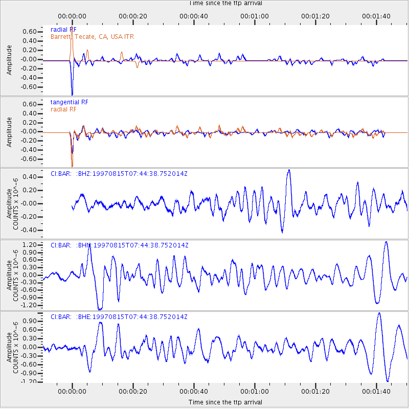
BAR Barrett, Tecate, CA, USA - Earthquake Result Viewer
*The percent match for this event was below the threshold and hence no stack was calculated.
| Earthquake location: |
Central East Pacific Rise |
| Earthquake latitude/longitude: |
-4.4/-105.7 |
| Earthquake time(UTC): |
1997/08/15 (227) 07:37:49 GMT |
| Earthquake Depth: |
10 km |
| Earthquake Magnitude: |
5.3 MB, 5.8 MS, 6.2 UNKNOWN, 6.1 MW |
| Earthquake Catalog/Contributor: |
WHDF/NEIC |
|
| Network: |
CI Caltech Regional Seismic Network |
| Station: |
BAR Barrett, Tecate, CA, USA |
| Lat/Lon: |
32.68 N/116.67 W |
| Elevation: |
521 m |
|
| Distance: |
38.3 deg |
| Az: |
344.985 deg |
| Baz: |
162.163 deg |
| Ray Param: |
$rayparam |
*The percent match for this event was below the threshold and hence was not used in the summary stack. |
|
| Radial Match: |
85.32959 % |
| Radial Bump: |
285 |
| Transverse Match: |
80.580826 % |
| Transverse Bump: |
400 |
| SOD ConfigId: |
4480 |
| Insert Time: |
2010-02-26 00:11:48.092 +0000 |
| GWidth: |
2.5 |
| Max Bumps: |
400 |
| Tol: |
0.001 |
|
Signal To Noise
| Channel | StoN | STA | LTA |
| CI:BAR: :BHN:19970815T07:44:38.752014Z | 1.8510196 | 2.0344905E-7 | 1.0991188E-7 |
| CI:BAR: :BHE:19970815T07:44:38.752014Z | 1.3503797 | 9.7668675E-8 | 7.232683E-8 |
| CI:BAR: :BHZ:19970815T07:44:38.752014Z | 1.5100269 | 8.741162E-8 | 5.788746E-8 |
| Arrivals |
| Ps | |
| PpPs | |
| PsPs/PpSs | |


