You are here: Home > Network List > XD14 - Illuminating the architecture of the greater Mount St. Helens magmatic systems f Stations List
> Station MG06 "Mount St Helens, WA" > Earthquake Result Viewer
MG06 "Mount St Helens, WA" - Earthquake Result Viewer
| Earthquake location: |
Near S. Coast Of Western Honshu |
| Earthquake latitude/longitude: |
33.4/136.4 |
| Earthquake time(UTC): |
2016/04/01 (092) 02:39:07 GMT |
| Earthquake Depth: |
10 km |
| Earthquake Magnitude: |
6.0 MWP |
| Earthquake Catalog/Contributor: |
NEIC PDE/NEIC COMCAT |
|
| Network: |
XD Illuminating the architecture of the greater Mount St. Helens magmatic systems f |
| Station: |
MG06 "Mount St Helens, WA" |
| Lat/Lon: |
46.35 N/122.22 W |
| Elevation: |
1408 m |
|
| Distance: |
73.7 deg |
| Az: |
45.033 deg |
| Baz: |
301.271 deg |
| Ray Param: |
0.052828196 |
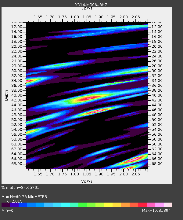
| Estimated Moho Depth: |
69.75 km |
| Estimated Crust Vp/Vs: |
2.02 |
| Assumed Crust Vp: |
6.566 km/s |
| Estimated Crust Vs: |
3.259 km/s |
| Estimated Crust Poisson's Ratio: |
0.34 |
|
| Radial Match: |
84.65761 % |
| Radial Bump: |
340 |
| Transverse Match: |
77.106384 % |
| Transverse Bump: |
400 |
| SOD ConfigId: |
7422571 |
| Insert Time: |
2019-04-22 03:09:33.621 +0000 |
| GWidth: |
2.5 |
| Max Bumps: |
400 |
| Tol: |
0.001 |
|

Signal To Noise
| Channel | StoN | STA | LTA |
| XD:MG06: :BHZ:20160401T02:50:10.065027Z | 2.0798025 | 4.4607634E-7 | 2.1448015E-7 |
| XD:MG06: :BHN:20160401T02:50:10.065027Z | 1.6496758 | 2.1472114E-7 | 1.3015959E-7 |
| XD:MG06: :BHE:20160401T02:50:10.065027Z | 1.9055082 | 3.0571593E-7 | 1.60438E-7 |
| Arrivals |
| Ps | 11 SECOND |
| PpPs | 31 SECOND |
| PsPs/PpSs | 42 SECOND |


