You are here: Home > Network List > IU - Global Seismograph Network (GSN - IRIS/USGS) Stations List
> Station CTAO Charters Towers, Australia > Earthquake Result Viewer
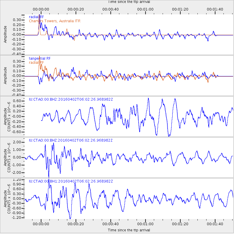
CTAO Charters Towers, Australia - Earthquake Result Viewer
*The percent match for this event was below the threshold and hence no stack was calculated.
| Earthquake location: |
Alaska Peninsula |
| Earthquake latitude/longitude: |
57.0/-158.0 |
| Earthquake time(UTC): |
2016/04/02 (093) 05:50:00 GMT |
| Earthquake Depth: |
10 km |
| Earthquake Magnitude: |
6.2 MWP, 6.4 MI |
| Earthquake Catalog/Contributor: |
NEIC PDE/NEIC COMCAT |
|
| Network: |
IU Global Seismograph Network (GSN - IRIS/USGS) |
| Station: |
CTAO Charters Towers, Australia |
| Lat/Lon: |
20.09 S/146.25 E |
| Elevation: |
357 m |
|
| Distance: |
89.8 deg |
| Az: |
231.015 deg |
| Baz: |
26.875 deg |
| Ray Param: |
$rayparam |
*The percent match for this event was below the threshold and hence was not used in the summary stack. |
|
| Radial Match: |
70.3729 % |
| Radial Bump: |
400 |
| Transverse Match: |
81.758804 % |
| Transverse Bump: |
399 |
| SOD ConfigId: |
7422571 |
| Insert Time: |
2019-04-22 03:20:00.869 +0000 |
| GWidth: |
2.5 |
| Max Bumps: |
400 |
| Tol: |
0.001 |
|
Signal To Noise
| Channel | StoN | STA | LTA |
| IU:CTAO:00:BHZ:20160402T06:02:26.968982Z | 5.6127586 | 9.769126E-7 | 1.7405212E-7 |
| IU:CTAO:00:BH1:20160402T06:02:26.968982Z | 4.0599217 | 4.9787354E-7 | 1.2263132E-7 |
| IU:CTAO:00:BH2:20160402T06:02:26.968982Z | 2.322785 | 3.4776056E-7 | 1.4971708E-7 |
| Arrivals |
| Ps | |
| PpPs | |
| PsPs/PpSs | |


