You are here: Home > Network List > KN - Kyrgyz Seismic Telemetry Network Stations List
> Station CHM KN.CHM > Earthquake Result Viewer
CHM KN.CHM - Earthquake Result Viewer
*The percent match for this event was below the threshold and hence no stack was calculated.
| Earthquake location: |
Alaska Peninsula |
| Earthquake latitude/longitude: |
57.0/-158.0 |
| Earthquake time(UTC): |
2016/04/02 (093) 05:50:00 GMT |
| Earthquake Depth: |
10 km |
| Earthquake Magnitude: |
6.2 MWP, 6.4 MI |
| Earthquake Catalog/Contributor: |
NEIC PDE/NEIC COMCAT |
|
| Network: |
KN Kyrgyz Seismic Telemetry Network |
| Station: |
CHM KN.CHM |
| Lat/Lon: |
43.00 N/74.75 E |
| Elevation: |
655 m |
|
| Distance: |
71.0 deg |
| Az: |
321.876 deg |
| Baz: |
27.385 deg |
| Ray Param: |
$rayparam |
*The percent match for this event was below the threshold and hence was not used in the summary stack. |
|
| Radial Match: |
43.873775 % |
| Radial Bump: |
400 |
| Transverse Match: |
35.767895 % |
| Transverse Bump: |
400 |
| SOD ConfigId: |
7422571 |
| Insert Time: |
2019-04-22 03:20:24.140 +0000 |
| GWidth: |
2.5 |
| Max Bumps: |
400 |
| Tol: |
0.001 |
|
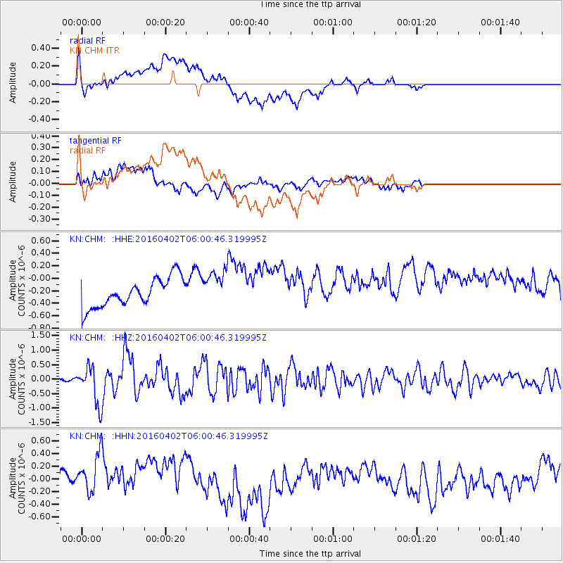
Signal To Noise
| Channel | StoN | STA | LTA |
| KN:CHM: :HHZ:20160402T06:00:46.319995Z | 9.040542 | 6.8397765E-7 | 7.565671E-8 |
| KN:CHM: :HHN:20160402T06:00:46.319995Z | 1.5942004 | 4.240977E-7 | 2.6602532E-7 |
| KN:CHM: :HHE:20160402T06:00:46.319995Z | 1.6204431 | 3.4993536E-7 | 2.1595042E-7 |
| Arrivals |
| Ps | |
| PpPs | |
| PsPs/PpSs | |


