You are here: Home > Network List > N4 - Central and EAstern US Network Stations List
> Station 143B Socs Landing, Pioneer, LA, USA > Earthquake Result Viewer
143B Socs Landing, Pioneer, LA, USA - Earthquake Result Viewer
| Earthquake location: |
Alaska Peninsula |
| Earthquake latitude/longitude: |
57.0/-158.0 |
| Earthquake time(UTC): |
2016/04/02 (093) 05:50:00 GMT |
| Earthquake Depth: |
10 km |
| Earthquake Magnitude: |
6.2 MWP, 6.4 MI |
| Earthquake Catalog/Contributor: |
NEIC PDE/NEIC COMCAT |
|
| Network: |
N4 Central and EAstern US Network |
| Station: |
143B Socs Landing, Pioneer, LA, USA |
| Lat/Lon: |
32.70 N/91.40 W |
| Elevation: |
31 m |
|
| Distance: |
50.7 deg |
| Az: |
89.041 deg |
| Baz: |
319.594 deg |
| Ray Param: |
0.0678953 |
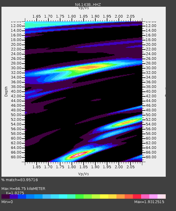
| Estimated Moho Depth: |
66.75 km |
| Estimated Crust Vp/Vs: |
1.83 |
| Assumed Crust Vp: |
6.201 km/s |
| Estimated Crust Vs: |
3.393 km/s |
| Estimated Crust Poisson's Ratio: |
0.29 |
|
| Radial Match: |
83.95716 % |
| Radial Bump: |
361 |
| Transverse Match: |
62.641506 % |
| Transverse Bump: |
297 |
| SOD ConfigId: |
7422571 |
| Insert Time: |
2019-04-22 03:21:26.702 +0000 |
| GWidth: |
2.5 |
| Max Bumps: |
400 |
| Tol: |
0.001 |
|

Signal To Noise
| Channel | StoN | STA | LTA |
| N4:143B: :HHZ:20160402T05:58:28.200Z | 7.130921 | 1.4814202E-6 | 2.07746E-7 |
| N4:143B: :HHN:20160402T05:58:28.200Z | 2.144282 | 8.9893894E-7 | 4.1922604E-7 |
| N4:143B: :HHE:20160402T05:58:28.200Z | 2.2521346 | 9.455603E-7 | 4.1985072E-7 |
| Arrivals |
| Ps | 9.4 SECOND |
| PpPs | 29 SECOND |
| PsPs/PpSs | 38 SECOND |


