You are here: Home > Network List > UU - University of Utah Regional Network Stations List
> Station PKCU Pink Cliffs, UT, USA > Earthquake Result Viewer
PKCU Pink Cliffs, UT, USA - Earthquake Result Viewer
| Earthquake location: |
Santa Cruz Islands |
| Earthquake latitude/longitude: |
-10.4/165.2 |
| Earthquake time(UTC): |
2015/07/18 (199) 02:27:33 GMT |
| Earthquake Depth: |
10 km |
| Earthquake Magnitude: |
7.0 MWW, 7.5 MI |
| Earthquake Catalog/Contributor: |
NEIC PDE/NEIC COMCAT |
|
| Network: |
UU University of Utah Regional Network |
| Station: |
PKCU Pink Cliffs, UT, USA |
| Lat/Lon: |
37.44 N/112.31 W |
| Elevation: |
2834 m |
|
| Distance: |
90.4 deg |
| Az: |
52.107 deg |
| Baz: |
257.238 deg |
| Ray Param: |
0.041675687 |
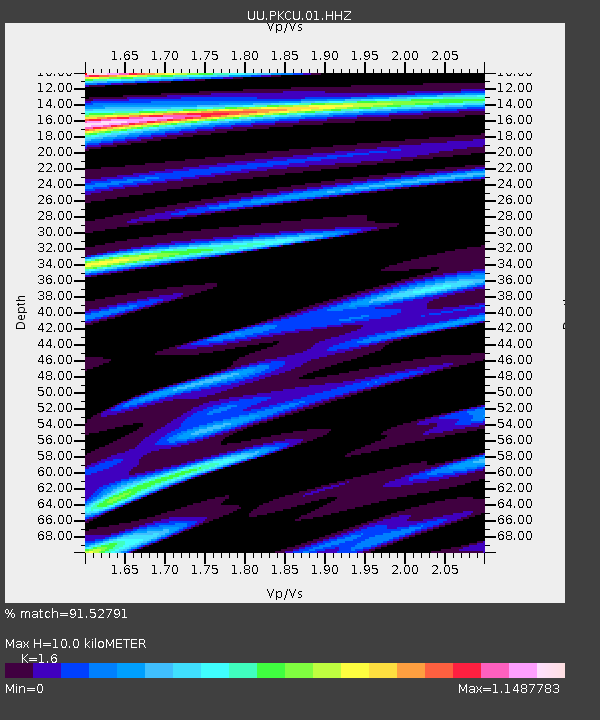
| Estimated Moho Depth: |
10.0 km |
| Estimated Crust Vp/Vs: |
1.60 |
| Assumed Crust Vp: |
6.194 km/s |
| Estimated Crust Vs: |
3.871 km/s |
| Estimated Crust Poisson's Ratio: |
0.18 |
|
| Radial Match: |
91.52791 % |
| Radial Bump: |
307 |
| Transverse Match: |
77.283066 % |
| Transverse Bump: |
340 |
| SOD ConfigId: |
1085051 |
| Insert Time: |
2015-08-01 02:55:44.242 +0000 |
| GWidth: |
2.5 |
| Max Bumps: |
400 |
| Tol: |
0.001 |
|

Signal To Noise
| Channel | StoN | STA | LTA |
| UU:PKCU:01:HHZ:20150718T02:40:03.460015Z | 5.983036 | 2.9184203E-8 | 4.8778253E-9 |
| UU:PKCU:01:HHN:20150718T02:40:03.460015Z | 1.4482448 | 1.13482805E-8 | 7.835885E-9 |
| UU:PKCU:01:HHE:20150718T02:40:03.460015Z | 0.66494226 | 8.883027E-9 | 1.3359095E-8 |
| Arrivals |
| Ps | 1.0 SECOND |
| PpPs | 4.1 SECOND |
| PsPs/PpSs | 5.1 SECOND |


