You are here: Home > Network List > NM - Cooperative New Madrid Seismic Network Stations List
> Station UTMT Martin, TN > Earthquake Result Viewer
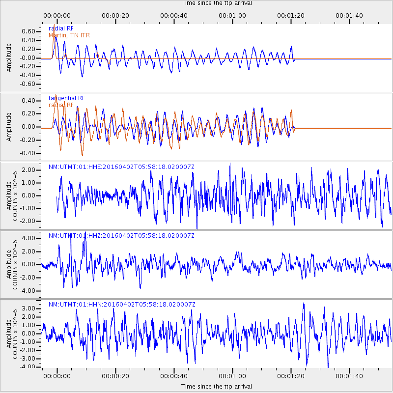
UTMT Martin, TN - Earthquake Result Viewer
*The percent match for this event was below the threshold and hence no stack was calculated.
| Earthquake location: |
Alaska Peninsula |
| Earthquake latitude/longitude: |
57.0/-158.0 |
| Earthquake time(UTC): |
2016/04/02 (093) 05:50:00 GMT |
| Earthquake Depth: |
10 km |
| Earthquake Magnitude: |
6.2 MWP, 6.4 MI |
| Earthquake Catalog/Contributor: |
NEIC PDE/NEIC COMCAT |
|
| Network: |
NM Cooperative New Madrid Seismic Network |
| Station: |
UTMT Martin, TN |
| Lat/Lon: |
36.35 N/88.86 W |
| Elevation: |
110 m |
|
| Distance: |
49.3 deg |
| Az: |
83.849 deg |
| Baz: |
317.689 deg |
| Ray Param: |
$rayparam |
*The percent match for this event was below the threshold and hence was not used in the summary stack. |
|
| Radial Match: |
73.95603 % |
| Radial Bump: |
400 |
| Transverse Match: |
52.99355 % |
| Transverse Bump: |
400 |
| SOD ConfigId: |
7422571 |
| Insert Time: |
2019-04-22 03:23:22.751 +0000 |
| GWidth: |
2.5 |
| Max Bumps: |
400 |
| Tol: |
0.001 |
|
Signal To Noise
| Channel | StoN | STA | LTA |
| NM:UTMT:01:HHZ:20160402T05:58:18.020007Z | 6.59479 | 1.7744217E-6 | 2.6906417E-7 |
| NM:UTMT:01:HHN:20160402T05:58:18.020007Z | 1.0023507 | 6.324435E-7 | 6.309603E-7 |
| NM:UTMT:01:HHE:20160402T05:58:18.020007Z | 2.002915 | 1.0522991E-6 | 5.253838E-7 |
| Arrivals |
| Ps | |
| PpPs | |
| PsPs/PpSs | |


