You are here: Home > Network List > NN - Western Great Basin/Eastern Sierra Nevada Stations List
> Station S11A Rachel, NV, USA - NN reactivation > Earthquake Result Viewer
S11A Rachel, NV, USA - NN reactivation - Earthquake Result Viewer
| Earthquake location: |
Alaska Peninsula |
| Earthquake latitude/longitude: |
57.0/-158.0 |
| Earthquake time(UTC): |
2016/04/02 (093) 05:50:00 GMT |
| Earthquake Depth: |
10 km |
| Earthquake Magnitude: |
6.2 MWP, 6.4 MI |
| Earthquake Catalog/Contributor: |
NEIC PDE/NEIC COMCAT |
|
| Network: |
NN Western Great Basin/Eastern Sierra Nevada |
| Station: |
S11A Rachel, NV, USA - NN reactivation |
| Lat/Lon: |
37.64 N/115.75 W |
| Elevation: |
1456 m |
|
| Distance: |
33.8 deg |
| Az: |
106.697 deg |
| Baz: |
318.734 deg |
| Ray Param: |
0.07802675 |
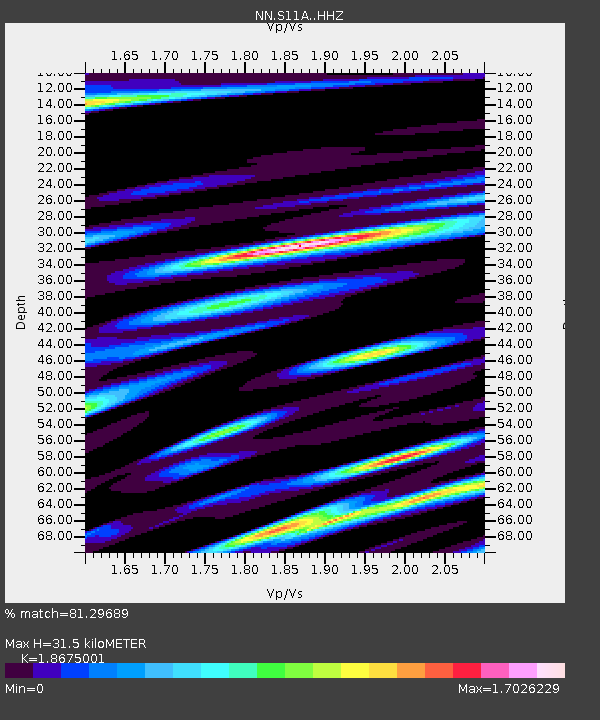
| Estimated Moho Depth: |
31.5 km |
| Estimated Crust Vp/Vs: |
1.87 |
| Assumed Crust Vp: |
6.276 km/s |
| Estimated Crust Vs: |
3.361 km/s |
| Estimated Crust Poisson's Ratio: |
0.30 |
|
| Radial Match: |
81.29689 % |
| Radial Bump: |
400 |
| Transverse Match: |
61.930725 % |
| Transverse Bump: |
400 |
| SOD ConfigId: |
7422571 |
| Insert Time: |
2019-04-22 03:23:38.340 +0000 |
| GWidth: |
2.5 |
| Max Bumps: |
400 |
| Tol: |
0.001 |
|

Signal To Noise
| Channel | StoN | STA | LTA |
| NN:S11A: :HHZ:20160402T05:56:11.197986Z | 5.1492777 | 9.49683E-7 | 1.8443033E-7 |
| NN:S11A: :HHN:20160402T05:56:11.197986Z | 2.8070364 | 7.5703144E-7 | 2.6969062E-7 |
| NN:S11A: :HHE:20160402T05:56:11.197986Z | 2.0831552 | 8.4416365E-7 | 4.0523324E-7 |
| Arrivals |
| Ps | 4.7 SECOND |
| PpPs | 13 SECOND |
| PsPs/PpSs | 18 SECOND |


