You are here: Home > Network List > UU - University of Utah Regional Network Stations List
> Station WPUT Wasatch Plateau, UT,USA > Earthquake Result Viewer
WPUT Wasatch Plateau, UT,USA - Earthquake Result Viewer
| Earthquake location: |
Santa Cruz Islands |
| Earthquake latitude/longitude: |
-10.4/165.2 |
| Earthquake time(UTC): |
2015/07/18 (199) 02:27:33 GMT |
| Earthquake Depth: |
10 km |
| Earthquake Magnitude: |
7.0 MWW, 7.5 MI |
| Earthquake Catalog/Contributor: |
NEIC PDE/NEIC COMCAT |
|
| Network: |
UU University of Utah Regional Network |
| Station: |
WPUT Wasatch Plateau, UT,USA |
| Lat/Lon: |
39.00 N/111.36 W |
| Elevation: |
2618 m |
|
| Distance: |
91.5 deg |
| Az: |
50.754 deg |
| Baz: |
257.847 deg |
| Ray Param: |
0.04159959 |
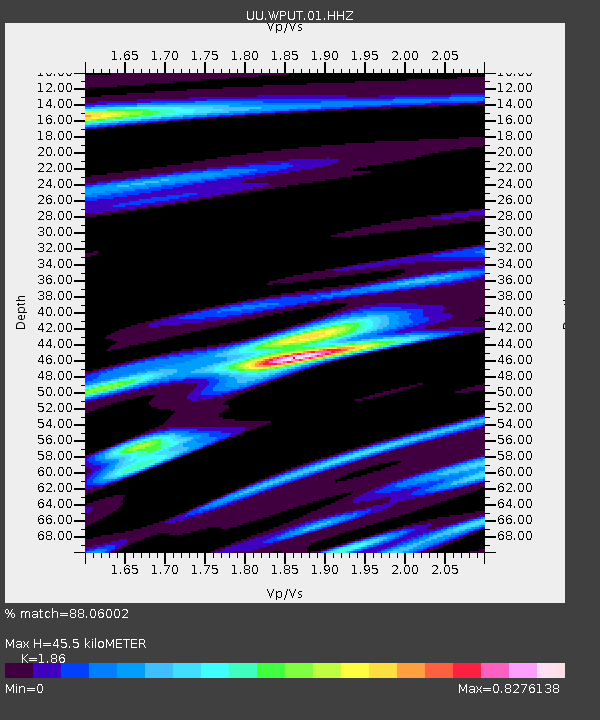
| Estimated Moho Depth: |
45.5 km |
| Estimated Crust Vp/Vs: |
1.86 |
| Assumed Crust Vp: |
6.207 km/s |
| Estimated Crust Vs: |
3.337 km/s |
| Estimated Crust Poisson's Ratio: |
0.30 |
|
| Radial Match: |
88.06002 % |
| Radial Bump: |
400 |
| Transverse Match: |
86.36209 % |
| Transverse Bump: |
277 |
| SOD ConfigId: |
1085051 |
| Insert Time: |
2015-08-01 02:56:23.863 +0000 |
| GWidth: |
2.5 |
| Max Bumps: |
400 |
| Tol: |
0.001 |
|

Signal To Noise
| Channel | StoN | STA | LTA |
| UU:WPUT:01:HHZ:20150718T02:40:08.400017Z | 4.724762 | 2.6876055E-8 | 5.6883405E-9 |
| UU:WPUT:01:HHN:20150718T02:40:08.400017Z | 0.7856223 | 4.531861E-9 | 5.7684986E-9 |
| UU:WPUT:01:HHE:20150718T02:40:08.400017Z | 1.1697744 | 8.421455E-9 | 7.1992123E-9 |
| Arrivals |
| Ps | 6.4 SECOND |
| PpPs | 21 SECOND |
| PsPs/PpSs | 27 SECOND |


