You are here: Home > Network List > TA - USArray Transportable Network (new EarthScope stations) Stations List
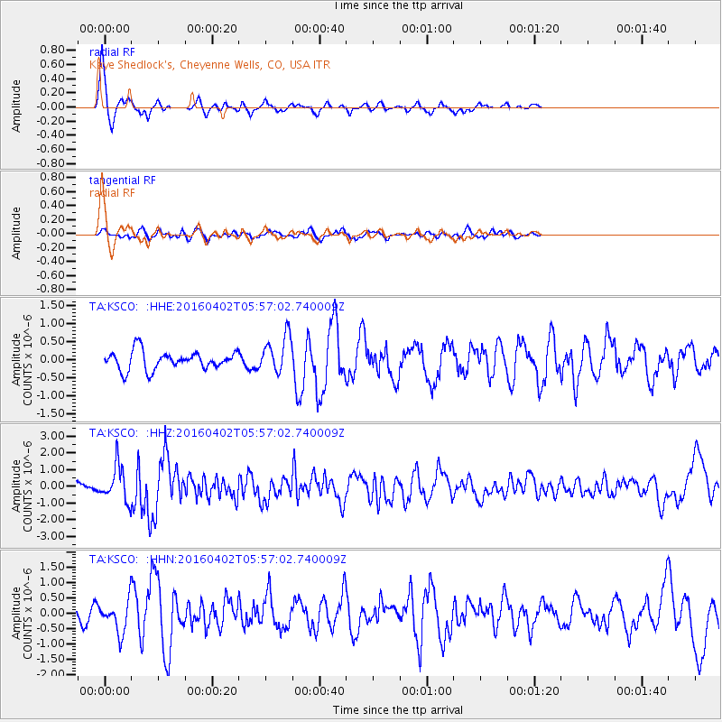
> Station KSCO Kaye Shedlock's, Cheyenne Wells, CO, USA > Earthquake Result Viewer
KSCO Kaye Shedlock's, Cheyenne Wells, CO, USA - Earthquake Result Viewer
| Earthquake location: |
Alaska Peninsula |
| Earthquake latitude/longitude: |
57.0/-158.0 |
| Earthquake time(UTC): |
2016/04/02 (093) 05:50:00 GMT |
| Earthquake Depth: |
10 km |
| Earthquake Magnitude: |
6.2 MWP, 6.4 MI |
| Earthquake Catalog/Contributor: |
NEIC PDE/NEIC COMCAT |
|
| Network: |
TA USArray Transportable Network (new EarthScope stations) |
| Station: |
KSCO Kaye Shedlock's, Cheyenne Wells, CO, USA |
| Lat/Lon: |
39.01 N/102.63 W |
| Elevation: |
1382 m |
|
| Distance: |
39.9 deg |
| Az: |
92.546 deg |
| Baz: |
315.501 deg |
| Ray Param: |
0.07471651 |
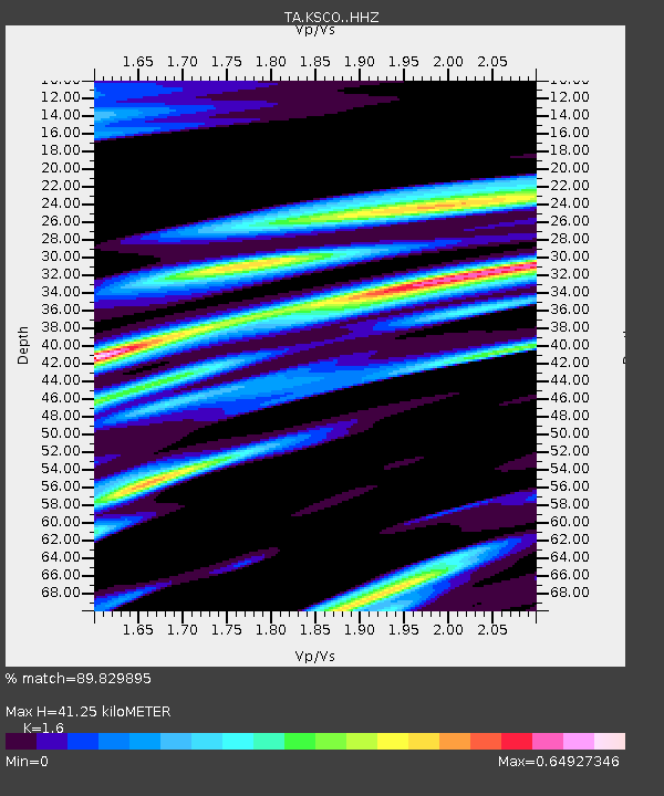
| Estimated Moho Depth: |
41.25 km |
| Estimated Crust Vp/Vs: |
1.60 |
| Assumed Crust Vp: |
6.242 km/s |
| Estimated Crust Vs: |
3.901 km/s |
| Estimated Crust Poisson's Ratio: |
0.18 |
|
| Radial Match: |
89.829895 % |
| Radial Bump: |
269 |
| Transverse Match: |
60.620083 % |
| Transverse Bump: |
384 |
| SOD ConfigId: |
7422571 |
| Insert Time: |
2019-04-22 03:25:31.260 +0000 |
| GWidth: |
2.5 |
| Max Bumps: |
400 |
| Tol: |
0.001 |
|
Signal To Noise
| Channel | StoN | STA | LTA |
| TA:KSCO: :HHZ:20160402T05:57:02.740009Z | 7.0450006 | 1.0667617E-6 | 1.5142109E-7 |
| TA:KSCO: :HHN:20160402T05:57:02.740009Z | 1.8237991 | 5.3626616E-7 | 2.9403793E-7 |
| TA:KSCO: :HHE:20160402T05:57:02.740009Z | 2.2964964 | 5.8694576E-7 | 2.5558313E-7 |
| Arrivals |
| Ps | 4.3 SECOND |
| PpPs | 16 SECOND |
| PsPs/PpSs | 20 SECOND |


