You are here: Home > Network List > TM - Thai Seismic Monitoring Network Stations List
> Station PHRA PHRA staion > Earthquake Result Viewer
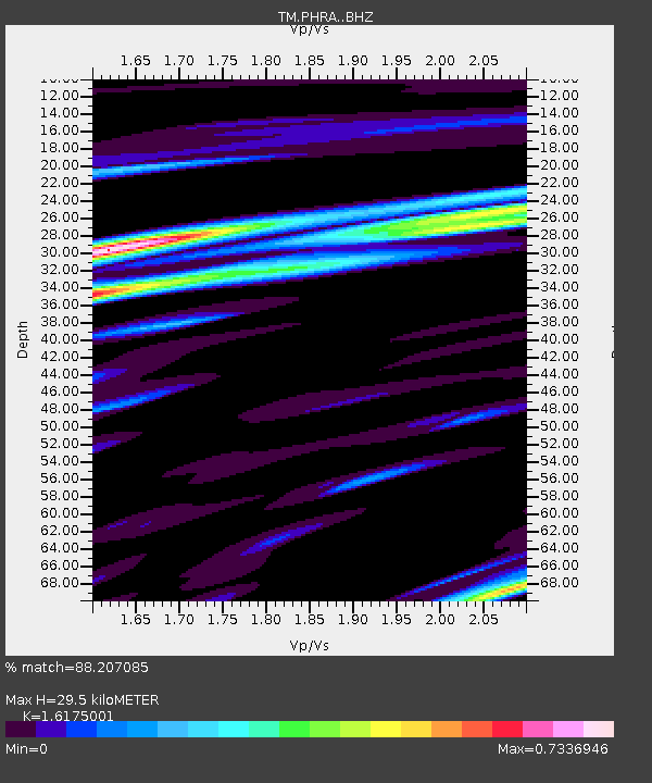
PHRA PHRA staion - Earthquake Result Viewer
| Earthquake location: |
Alaska Peninsula |
| Earthquake latitude/longitude: |
57.0/-158.0 |
| Earthquake time(UTC): |
2016/04/02 (093) 05:50:00 GMT |
| Earthquake Depth: |
10 km |
| Earthquake Magnitude: |
6.2 MWP, 6.4 MI |
| Earthquake Catalog/Contributor: |
NEIC PDE/NEIC COMCAT |
|
| Network: |
TM Thai Seismic Monitoring Network |
| Station: |
PHRA PHRA staion |
| Lat/Lon: |
18.50 N/100.23 E |
| Elevation: |
187 m |
|
| Distance: |
80.9 deg |
| Az: |
289.839 deg |
| Baz: |
32.806 deg |
| Ray Param: |
0.04795182 |
| Estimated Moho Depth: |
29.5 km |
| Estimated Crust Vp/Vs: |
1.62 |
| Assumed Crust Vp: |
6.35 km/s |
| Estimated Crust Vs: |
3.926 km/s |
| Estimated Crust Poisson's Ratio: |
0.19 |
|
| Radial Match: |
88.207085 % |
| Radial Bump: |
400 |
| Transverse Match: |
65.98463 % |
| Transverse Bump: |
400 |
| SOD ConfigId: |
7422571 |
| Insert Time: |
2019-04-22 03:26:06.287 +0000 |
| GWidth: |
2.5 |
| Max Bumps: |
400 |
| Tol: |
0.001 |
|

Signal To Noise
| Channel | StoN | STA | LTA |
| TM:PHRA: :BHZ:20160402T06:01:42.819995Z | 5.076736 | 5.18653E-6 | 1.0216269E-6 |
| TM:PHRA: :BHN:20160402T06:01:42.819995Z | 3.1157398 | 1.687954E-6 | 5.4175064E-7 |
| TM:PHRA: :BHE:20160402T06:01:42.819995Z | 2.797002 | 1.7319597E-6 | 6.1922003E-7 |
| Arrivals |
| Ps | 3.0 SECOND |
| PpPs | 12 SECOND |
| PsPs/PpSs | 15 SECOND |


