You are here: Home > Network List > XL12 - Hangay Dome, Mongolia Stations List
> Station HV09 HV09 > Earthquake Result Viewer
HV09 HV09 - Earthquake Result Viewer
| Earthquake location: |
Alaska Peninsula |
| Earthquake latitude/longitude: |
57.0/-158.0 |
| Earthquake time(UTC): |
2016/04/02 (093) 05:50:00 GMT |
| Earthquake Depth: |
10 km |
| Earthquake Magnitude: |
6.2 MWP, 6.4 MI |
| Earthquake Catalog/Contributor: |
NEIC PDE/NEIC COMCAT |
|
| Network: |
XL Hangay Dome, Mongolia |
| Station: |
HV09 HV09 |
| Lat/Lon: |
50.16 N/99.50 E |
| Elevation: |
1980 m |
|
| Distance: |
55.6 deg |
| Az: |
310.465 deg |
| Baz: |
40.284 deg |
| Ray Param: |
0.06468327 |
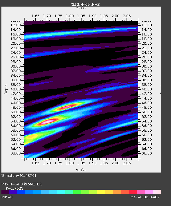
| Estimated Moho Depth: |
54.0 km |
| Estimated Crust Vp/Vs: |
1.70 |
| Assumed Crust Vp: |
6.622 km/s |
| Estimated Crust Vs: |
3.89 km/s |
| Estimated Crust Poisson's Ratio: |
0.24 |
|
| Radial Match: |
91.48761 % |
| Radial Bump: |
272 |
| Transverse Match: |
68.8253 % |
| Transverse Bump: |
400 |
| SOD ConfigId: |
7422571 |
| Insert Time: |
2019-04-22 03:27:04.223 +0000 |
| GWidth: |
2.5 |
| Max Bumps: |
400 |
| Tol: |
0.001 |
|

Signal To Noise
| Channel | StoN | STA | LTA |
| XL:HV09: :HHZ:20160402T05:59:04.739978Z | 13.473396 | 5.8756484E-7 | 4.3609262E-8 |
| XL:HV09: :HHN:20160402T05:59:04.739978Z | 6.898355 | 2.1816629E-7 | 3.1625845E-8 |
| XL:HV09: :HHE:20160402T05:59:04.739978Z | 8.261524 | 2.185898E-7 | 2.6458775E-8 |
| Arrivals |
| Ps | 6.1 SECOND |
| PpPs | 21 SECOND |
| PsPs/PpSs | 27 SECOND |


