You are here: Home > Network List > AU - Australian Seismological Centre Stations List
> Station XMIS Christmas Island Grants Well > Earthquake Result Viewer
XMIS Christmas Island Grants Well - Earthquake Result Viewer
| Earthquake location: |
Vanuatu Islands |
| Earthquake latitude/longitude: |
-14.4/166.8 |
| Earthquake time(UTC): |
2016/04/03 (094) 08:23:53 GMT |
| Earthquake Depth: |
35 km |
| Earthquake Magnitude: |
6.9 MWW, 7.2 MI |
| Earthquake Catalog/Contributor: |
NEIC PDE/NEIC COMCAT |
|
| Network: |
AU Australian Seismological Centre |
| Station: |
XMIS Christmas Island Grants Well |
| Lat/Lon: |
10.48 S/105.65 E |
| Elevation: |
210 m |
|
| Distance: |
59.7 deg |
| Az: |
266.127 deg |
| Baz: |
100.528 deg |
| Ray Param: |
0.061939806 |
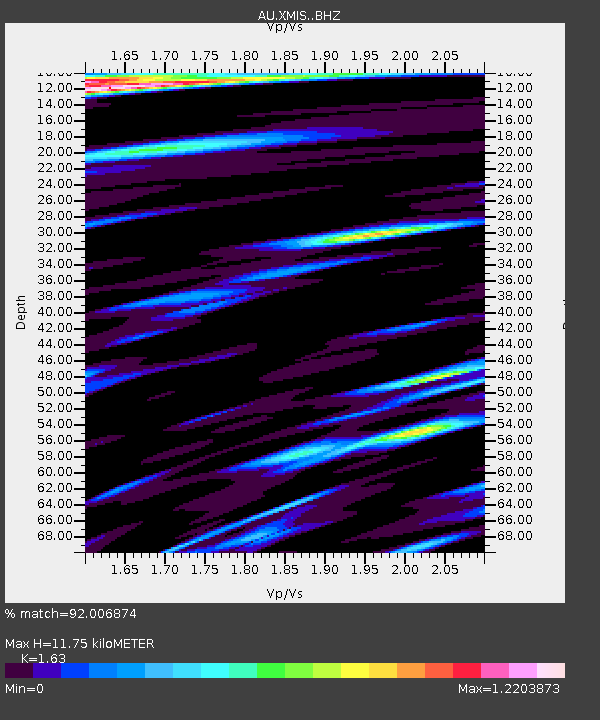
| Estimated Moho Depth: |
11.75 km |
| Estimated Crust Vp/Vs: |
1.63 |
| Assumed Crust Vp: |
4.157 km/s |
| Estimated Crust Vs: |
2.55 km/s |
| Estimated Crust Poisson's Ratio: |
0.20 |
|
| Radial Match: |
92.006874 % |
| Radial Bump: |
400 |
| Transverse Match: |
81.769714 % |
| Transverse Bump: |
400 |
| SOD ConfigId: |
7422571 |
| Insert Time: |
2019-04-22 03:29:39.023 +0000 |
| GWidth: |
2.5 |
| Max Bumps: |
400 |
| Tol: |
0.001 |
|

Signal To Noise
| Channel | StoN | STA | LTA |
| AU:XMIS: :BHZ:20160403T08:33:23.969006Z | 6.8657656 | 4.4791036E-6 | 6.5238225E-7 |
| AU:XMIS: :BHN:20160403T08:33:23.969006Z | 1.8806734 | 1.2403038E-6 | 6.5949985E-7 |
| AU:XMIS: :BHE:20160403T08:33:23.969006Z | 7.974934 | 3.2795112E-6 | 4.1122738E-7 |
| Arrivals |
| Ps | 1.8 SECOND |
| PpPs | 7.3 SECOND |
| PsPs/PpSs | 9.1 SECOND |


