You are here: Home > Network List > CC - Cascade Chain Volcano Monitoring Stations List
> Station CIHL Cinder Hill, Newberry, OR > Earthquake Result Viewer
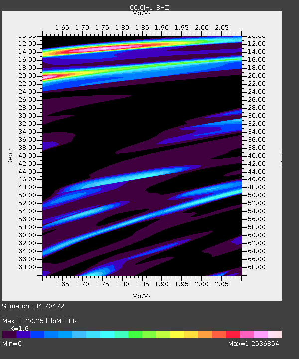
CIHL Cinder Hill, Newberry, OR - Earthquake Result Viewer
| Earthquake location: |
Vanuatu Islands |
| Earthquake latitude/longitude: |
-14.4/166.8 |
| Earthquake time(UTC): |
2016/04/03 (094) 08:23:53 GMT |
| Earthquake Depth: |
35 km |
| Earthquake Magnitude: |
6.9 MWW, 7.2 MI |
| Earthquake Catalog/Contributor: |
NEIC PDE/NEIC COMCAT |
|
| Network: |
CC Cascade Chain Volcano Monitoring |
| Station: |
CIHL Cinder Hill, Newberry, OR |
| Lat/Lon: |
43.75 N/121.15 W |
| Elevation: |
1966 m |
|
| Distance: |
87.3 deg |
| Az: |
43.637 deg |
| Baz: |
247.359 deg |
| Ray Param: |
0.043370817 |
| Estimated Moho Depth: |
20.25 km |
| Estimated Crust Vp/Vs: |
1.60 |
| Assumed Crust Vp: |
6.597 km/s |
| Estimated Crust Vs: |
4.123 km/s |
| Estimated Crust Poisson's Ratio: |
0.18 |
|
| Radial Match: |
84.70472 % |
| Radial Bump: |
400 |
| Transverse Match: |
65.37493 % |
| Transverse Bump: |
400 |
| SOD ConfigId: |
7422571 |
| Insert Time: |
2019-04-22 03:30:29.748 +0000 |
| GWidth: |
2.5 |
| Max Bumps: |
400 |
| Tol: |
0.001 |
|

Signal To Noise
| Channel | StoN | STA | LTA |
| CC:CIHL: :BHZ:20160403T08:36:05.120007Z | 11.770057 | 2.851657E-6 | 2.4228063E-7 |
| CC:CIHL: :BHN:20160403T08:36:05.120007Z | 1.9121124 | 7.2178653E-7 | 3.7748126E-7 |
| CC:CIHL: :BHE:20160403T08:36:05.120007Z | 3.7555447 | 9.549306E-7 | 2.5427218E-7 |
| Arrivals |
| Ps | 1.9 SECOND |
| PpPs | 7.8 SECOND |
| PsPs/PpSs | 9.7 SECOND |


