You are here: Home > Network List > CC - Cascade Chain Volcano Monitoring Stations List
> Station SHRK Shell Rock, OR, USA > Earthquake Result Viewer
SHRK Shell Rock, OR, USA - Earthquake Result Viewer
| Earthquake location: |
Vanuatu Islands |
| Earthquake latitude/longitude: |
-14.4/166.8 |
| Earthquake time(UTC): |
2016/04/03 (094) 08:23:53 GMT |
| Earthquake Depth: |
35 km |
| Earthquake Magnitude: |
6.9 MWW, 7.2 MI |
| Earthquake Catalog/Contributor: |
NEIC PDE/NEIC COMCAT |
|
| Network: |
CC Cascade Chain Volcano Monitoring |
| Station: |
SHRK Shell Rock, OR, USA |
| Lat/Lon: |
45.46 N/121.53 W |
| Elevation: |
1319 m |
|
| Distance: |
87.7 deg |
| Az: |
41.951 deg |
| Baz: |
247.019 deg |
| Ray Param: |
0.043070834 |
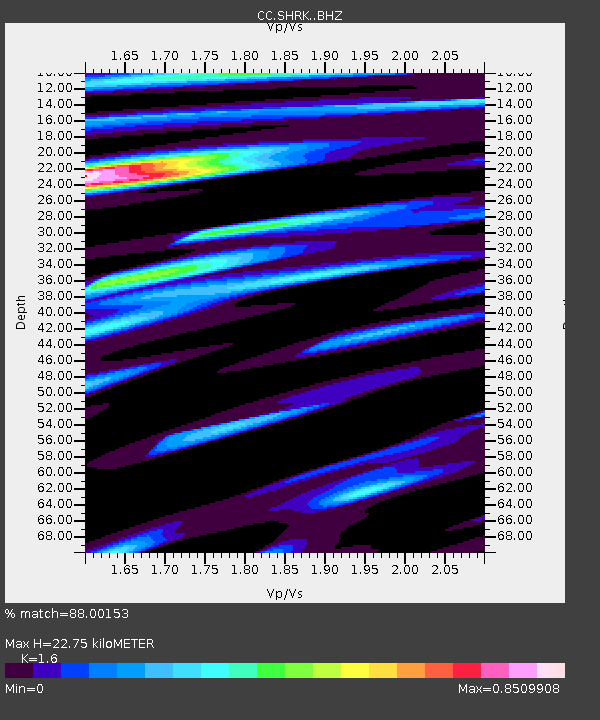
| Estimated Moho Depth: |
22.75 km |
| Estimated Crust Vp/Vs: |
1.60 |
| Assumed Crust Vp: |
6.597 km/s |
| Estimated Crust Vs: |
4.123 km/s |
| Estimated Crust Poisson's Ratio: |
0.18 |
|
| Radial Match: |
88.00153 % |
| Radial Bump: |
400 |
| Transverse Match: |
83.91971 % |
| Transverse Bump: |
400 |
| SOD ConfigId: |
7422571 |
| Insert Time: |
2019-04-22 03:30:34.596 +0000 |
| GWidth: |
2.5 |
| Max Bumps: |
400 |
| Tol: |
0.001 |
|

Signal To Noise
| Channel | StoN | STA | LTA |
| CC:SHRK: :BHZ:20160403T08:36:07.094983Z | 18.579016 | 2.8468696E-6 | 1.5323039E-7 |
| CC:SHRK: :BHN:20160403T08:36:07.094983Z | 3.9879086 | 8.222728E-7 | 2.061915E-7 |
| CC:SHRK: :BHE:20160403T08:36:07.094983Z | 1.5673447 | 3.617308E-7 | 2.3079211E-7 |
| Arrivals |
| Ps | 2.1 SECOND |
| PpPs | 8.7 SECOND |
| PsPs/PpSs | 11 SECOND |


