You are here: Home > Network List > CN - Canadian National Seismograph Network Stations List
> Station DIB DAWSON INLET, BC > Earthquake Result Viewer
DIB DAWSON INLET, BC - Earthquake Result Viewer
| Earthquake location: |
Vanuatu Islands |
| Earthquake latitude/longitude: |
-14.4/166.8 |
| Earthquake time(UTC): |
2016/04/03 (094) 08:23:53 GMT |
| Earthquake Depth: |
35 km |
| Earthquake Magnitude: |
6.9 MWW, 7.2 MI |
| Earthquake Catalog/Contributor: |
NEIC PDE/NEIC COMCAT |
|
| Network: |
CN Canadian National Seismograph Network |
| Station: |
DIB DAWSON INLET, BC |
| Lat/Lon: |
53.20 N/132.48 W |
| Elevation: |
68 m |
|
| Distance: |
84.9 deg |
| Az: |
31.782 deg |
| Baz: |
238.055 deg |
| Ray Param: |
0.045088626 |
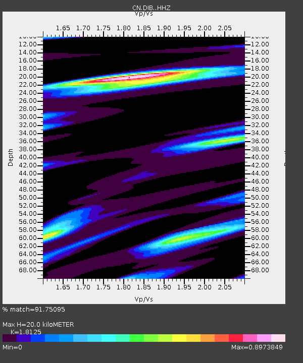
| Estimated Moho Depth: |
20.0 km |
| Estimated Crust Vp/Vs: |
1.81 |
| Assumed Crust Vp: |
6.183 km/s |
| Estimated Crust Vs: |
3.411 km/s |
| Estimated Crust Poisson's Ratio: |
0.28 |
|
| Radial Match: |
91.75095 % |
| Radial Bump: |
400 |
| Transverse Match: |
76.63896 % |
| Transverse Bump: |
400 |
| SOD ConfigId: |
7422571 |
| Insert Time: |
2019-04-22 03:31:44.939 +0000 |
| GWidth: |
2.5 |
| Max Bumps: |
400 |
| Tol: |
0.001 |
|

Signal To Noise
| Channel | StoN | STA | LTA |
| CN:DIB: :HHZ:20160403T08:35:53.380017Z | 12.967305 | 3.3698623E-6 | 2.5987376E-7 |
| CN:DIB: :HHN:20160403T08:35:53.380017Z | 2.9594922 | 5.989263E-7 | 2.0237468E-7 |
| CN:DIB: :HHE:20160403T08:35:53.380017Z | 6.183967 | 1.278208E-6 | 2.066971E-7 |
| Arrivals |
| Ps | 2.7 SECOND |
| PpPs | 8.9 SECOND |
| PsPs/PpSs | 12 SECOND |


