You are here: Home > Network List > PB - Plate Boundary Observatory Borehole Seismic Network Stations List
> Station B082 pathfi082bcs2006, Anza, CA, USA > Earthquake Result Viewer
B082 pathfi082bcs2006, Anza, CA, USA - Earthquake Result Viewer
| Earthquake location: |
Vanuatu Islands |
| Earthquake latitude/longitude: |
-14.4/166.8 |
| Earthquake time(UTC): |
2016/04/03 (094) 08:23:53 GMT |
| Earthquake Depth: |
35 km |
| Earthquake Magnitude: |
6.9 MWW, 7.2 MI |
| Earthquake Catalog/Contributor: |
NEIC PDE/NEIC COMCAT |
|
| Network: |
PB Plate Boundary Observatory Borehole Seismic Network |
| Station: |
B082 pathfi082bcs2006, Anza, CA, USA |
| Lat/Lon: |
33.60 N/116.60 W |
| Elevation: |
1375 m |
|
| Distance: |
87.0 deg |
| Az: |
54.387 deg |
| Baz: |
250.738 deg |
| Ray Param: |
0.04358146 |
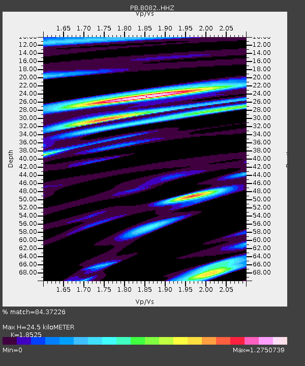
| Estimated Moho Depth: |
24.5 km |
| Estimated Crust Vp/Vs: |
1.85 |
| Assumed Crust Vp: |
6.264 km/s |
| Estimated Crust Vs: |
3.381 km/s |
| Estimated Crust Poisson's Ratio: |
0.29 |
|
| Radial Match: |
84.37226 % |
| Radial Bump: |
400 |
| Transverse Match: |
77.87757 % |
| Transverse Bump: |
400 |
| SOD ConfigId: |
7422571 |
| Insert Time: |
2019-04-22 03:33:55.780 +0000 |
| GWidth: |
2.5 |
| Max Bumps: |
400 |
| Tol: |
0.001 |
|

Signal To Noise
| Channel | StoN | STA | LTA |
| PB:B082: :HHZ:20160403T08:36:03.693982Z | 7.484193 | 1.69388E-8 | 2.263277E-9 |
| PB:B082: :HH1:20160403T08:36:03.693982Z | 1.4321939 | 3.6521028E-9 | 2.5500058E-9 |
| PB:B082: :HH2:20160403T08:36:03.693982Z | 1.8074718 | 3.1911638E-9 | 1.76554E-9 |
| Arrivals |
| Ps | 3.4 SECOND |
| PpPs | 11 SECOND |
| PsPs/PpSs | 14 SECOND |


