You are here: Home > Network List > TA - USArray Transportable Network (new EarthScope stations) Stations List
> Station A04D Lummi Island, WA, USA > Earthquake Result Viewer
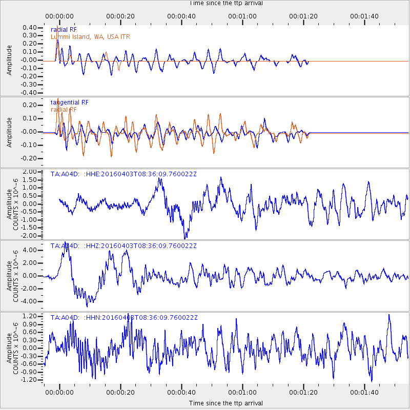
A04D Lummi Island, WA, USA - Earthquake Result Viewer
*The percent match for this event was below the threshold and hence no stack was calculated.
| Earthquake location: |
Vanuatu Islands |
| Earthquake latitude/longitude: |
-14.4/166.8 |
| Earthquake time(UTC): |
2016/04/03 (094) 08:23:53 GMT |
| Earthquake Depth: |
35 km |
| Earthquake Magnitude: |
6.9 MWW, 7.2 MI |
| Earthquake Catalog/Contributor: |
NEIC PDE/NEIC COMCAT |
|
| Network: |
TA USArray Transportable Network (new EarthScope stations) |
| Station: |
A04D Lummi Island, WA, USA |
| Lat/Lon: |
48.72 N/122.71 W |
| Elevation: |
13 m |
|
| Distance: |
88.3 deg |
| Az: |
38.64 deg |
| Baz: |
246.044 deg |
| Ray Param: |
$rayparam |
*The percent match for this event was below the threshold and hence was not used in the summary stack. |
|
| Radial Match: |
77.71033 % |
| Radial Bump: |
400 |
| Transverse Match: |
56.86927 % |
| Transverse Bump: |
400 |
| SOD ConfigId: |
7422571 |
| Insert Time: |
2019-04-22 03:34:30.603 +0000 |
| GWidth: |
2.5 |
| Max Bumps: |
400 |
| Tol: |
0.001 |
|
Signal To Noise
| Channel | StoN | STA | LTA |
| TA:A04D: :HHZ:20160403T08:36:09.760022Z | 11.383574 | 3.053061E-6 | 2.6819882E-7 |
| TA:A04D: :HHN:20160403T08:36:09.760022Z | 1.3615003 | 3.978493E-7 | 2.922139E-7 |
| TA:A04D: :HHE:20160403T08:36:09.760022Z | 3.9625514 | 9.45605E-7 | 2.3863538E-7 |
| Arrivals |
| Ps | |
| PpPs | |
| PsPs/PpSs | |


