You are here: Home > Network List > TA - USArray Transportable Network (new EarthScope stations) Stations List
> Station J04D Umpqua National Forest, Toketee, OR, USA > Earthquake Result Viewer
J04D Umpqua National Forest, Toketee, OR, USA - Earthquake Result Viewer

| Earthquake location: |
Vanuatu Islands |
| Earthquake latitude/longitude: |
-14.4/166.8 |
| Earthquake time(UTC): |
2016/04/03 (094) 08:23:53 GMT |
| Earthquake Depth: |
35 km |
| Earthquake Magnitude: |
6.9 MWW, 7.2 MI |
| Earthquake Catalog/Contributor: |
NEIC PDE/NEIC COMCAT |
|
| Network: |
TA USArray Transportable Network (new EarthScope stations) |
| Station: |
J04D Umpqua National Forest, Toketee, OR, USA |
| Lat/Lon: |
43.24 N/122.11 W |
| Elevation: |
1948 m |
|
| Distance: |
86.5 deg |
| Az: |
43.834 deg |
| Baz: |
246.71 deg |
| Ray Param: |
0.04398478 |
| Estimated Moho Depth: |
69.25 km |
| Estimated Crust Vp/Vs: |
1.89 |
| Assumed Crust Vp: |
6.522 km/s |
| Estimated Crust Vs: |
3.446 km/s |
| Estimated Crust Poisson's Ratio: |
0.31 |
|
| Radial Match: |
82.26047 % |
| Radial Bump: |
400 |
| Transverse Match: |
48.84396 % |
| Transverse Bump: |
400 |
| SOD ConfigId: |
7422571 |
| Insert Time: |
2019-04-22 03:34:50.056 +0000 |
| GWidth: |
2.5 |
| Max Bumps: |
400 |
| Tol: |
0.001 |
|
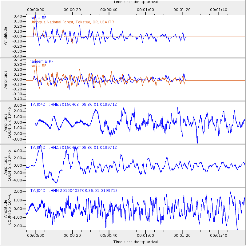
Signal To Noise
| Channel | StoN | STA | LTA |
| TA:J04D: :HHZ:20160403T08:36:01.019971Z | 12.207036 | 3.2963883E-6 | 2.7004E-7 |
| TA:J04D: :HHN:20160403T08:36:01.019971Z | 1.1765418 | 4.920166E-7 | 4.1818885E-7 |
| TA:J04D: :HHE:20160403T08:36:01.019971Z | 2.7276232 | 1.4372988E-6 | 5.2694185E-7 |
| Arrivals |
| Ps | 9.7 SECOND |
| PpPs | 30 SECOND |
| PsPs/PpSs | 40 SECOND |


