You are here: Home > Network List > TA - USArray Transportable Network (new EarthScope stations) Stations List
> Station J05D Fort Rock, OR, USA > Earthquake Result Viewer
J05D Fort Rock, OR, USA - Earthquake Result Viewer
| Earthquake location: |
Vanuatu Islands |
| Earthquake latitude/longitude: |
-14.4/166.8 |
| Earthquake time(UTC): |
2016/04/03 (094) 08:23:53 GMT |
| Earthquake Depth: |
35 km |
| Earthquake Magnitude: |
6.9 MWW, 7.2 MI |
| Earthquake Catalog/Contributor: |
NEIC PDE/NEIC COMCAT |
|
| Network: |
TA USArray Transportable Network (new EarthScope stations) |
| Station: |
J05D Fort Rock, OR, USA |
| Lat/Lon: |
43.28 N/121.23 W |
| Elevation: |
1541 m |
|
| Distance: |
87.1 deg |
| Az: |
44.043 deg |
| Baz: |
247.319 deg |
| Ray Param: |
0.043541532 |
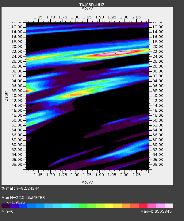
| Estimated Moho Depth: |
22.5 km |
| Estimated Crust Vp/Vs: |
1.96 |
| Assumed Crust Vp: |
6.597 km/s |
| Estimated Crust Vs: |
3.362 km/s |
| Estimated Crust Poisson's Ratio: |
0.32 |
|
| Radial Match: |
82.24244 % |
| Radial Bump: |
400 |
| Transverse Match: |
68.65123 % |
| Transverse Bump: |
400 |
| SOD ConfigId: |
7422571 |
| Insert Time: |
2019-04-22 03:34:52.283 +0000 |
| GWidth: |
2.5 |
| Max Bumps: |
400 |
| Tol: |
0.001 |
|

Signal To Noise
| Channel | StoN | STA | LTA |
| TA:J05D: :HHZ:20160403T08:36:03.959973Z | 15.86699 | 3.3941035E-6 | 2.1390973E-7 |
| TA:J05D: :HHN:20160403T08:36:03.959973Z | 1.4512208 | 4.6640872E-7 | 3.2139062E-7 |
| TA:J05D: :HHE:20160403T08:36:03.959973Z | 4.825592 | 1.0733596E-6 | 2.2243066E-7 |
| Arrivals |
| Ps | 3.4 SECOND |
| PpPs | 9.9 SECOND |
| PsPs/PpSs | 13 SECOND |


