You are here: Home > Network List > TA - USArray Transportable Network (new EarthScope stations) Stations List
> Station L20K Farewell, AK, USA > Earthquake Result Viewer
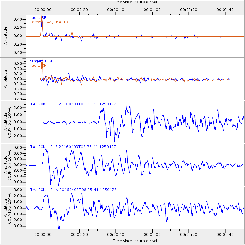
L20K Farewell, AK, USA - Earthquake Result Viewer

| Earthquake location: |
Vanuatu Islands |
| Earthquake latitude/longitude: |
-14.4/166.8 |
| Earthquake time(UTC): |
2016/04/03 (094) 08:23:53 GMT |
| Earthquake Depth: |
35 km |
| Earthquake Magnitude: |
6.9 MWW, 7.2 MI |
| Earthquake Catalog/Contributor: |
NEIC PDE/NEIC COMCAT |
|
| Network: |
TA USArray Transportable Network (new EarthScope stations) |
| Station: |
L20K Farewell, AK, USA |
| Lat/Lon: |
62.48 N/153.88 W |
| Elevation: |
673 m |
|
| Distance: |
82.5 deg |
| Az: |
17.262 deg |
| Baz: |
218.253 deg |
| Ray Param: |
0.046785835 |
| Estimated Moho Depth: |
22.5 km |
| Estimated Crust Vp/Vs: |
1.63 |
| Assumed Crust Vp: |
6.566 km/s |
| Estimated Crust Vs: |
4.035 km/s |
| Estimated Crust Poisson's Ratio: |
0.20 |
|
| Radial Match: |
97.90647 % |
| Radial Bump: |
277 |
| Transverse Match: |
89.79414 % |
| Transverse Bump: |
400 |
| SOD ConfigId: |
7422571 |
| Insert Time: |
2019-04-22 03:35:00.886 +0000 |
| GWidth: |
2.5 |
| Max Bumps: |
400 |
| Tol: |
0.001 |
|
Signal To Noise
| Channel | StoN | STA | LTA |
| TA:L20K: :BHZ:20160403T08:35:41.125012Z | 74.60317 | 6.372956E-6 | 8.542473E-8 |
| TA:L20K: :BHN:20160403T08:35:41.125012Z | 7.8717213 | 1.4950532E-6 | 1.8992709E-7 |
| TA:L20K: :BHE:20160403T08:35:41.125012Z | 12.27764 | 1.3134342E-6 | 1.0697774E-7 |
| Arrivals |
| Ps | 2.2 SECOND |
| PpPs | 8.7 SECOND |
| PsPs/PpSs | 11 SECOND |


