You are here: Home > Network List > TA - USArray Transportable Network (new EarthScope stations) Stations List
> Station MSTX Muleshoe, TX, USA > Earthquake Result Viewer
MSTX Muleshoe, TX, USA - Earthquake Result Viewer
*The percent match for this event was below the threshold and hence no stack was calculated.
| Earthquake location: |
Vanuatu Islands |
| Earthquake latitude/longitude: |
-14.4/166.8 |
| Earthquake time(UTC): |
2016/04/03 (094) 08:23:53 GMT |
| Earthquake Depth: |
35 km |
| Earthquake Magnitude: |
6.9 MWW, 7.2 MI |
| Earthquake Catalog/Contributor: |
NEIC PDE/NEIC COMCAT |
|
| Network: |
TA USArray Transportable Network (new EarthScope stations) |
| Station: |
MSTX Muleshoe, TX, USA |
| Lat/Lon: |
33.97 N/102.77 W |
| Elevation: |
1167 m |
|
| Distance: |
98.2 deg |
| Az: |
57.102 deg |
| Baz: |
258.29 deg |
| Ray Param: |
$rayparam |
*The percent match for this event was below the threshold and hence was not used in the summary stack. |
|
| Radial Match: |
59.544624 % |
| Radial Bump: |
400 |
| Transverse Match: |
56.382694 % |
| Transverse Bump: |
400 |
| SOD ConfigId: |
7422571 |
| Insert Time: |
2019-04-22 03:35:10.838 +0000 |
| GWidth: |
2.5 |
| Max Bumps: |
400 |
| Tol: |
0.001 |
|
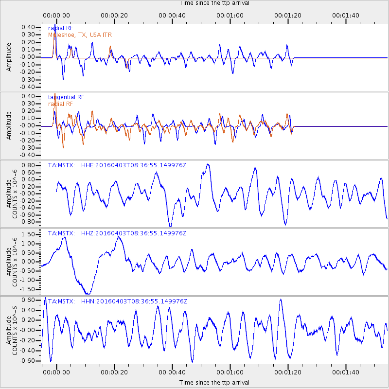
Signal To Noise
| Channel | StoN | STA | LTA |
| TA:MSTX: :HHZ:20160403T08:36:55.149976Z | 4.857107 | 9.3216465E-7 | 1.9191766E-7 |
| TA:MSTX: :HHN:20160403T08:36:55.149976Z | 1.1376467 | 1.9421168E-7 | 1.7071353E-7 |
| TA:MSTX: :HHE:20160403T08:36:55.149976Z | 1.3745809 | 3.4122792E-7 | 2.482414E-7 |
| Arrivals |
| Ps | |
| PpPs | |
| PsPs/PpSs | |


