You are here: Home > Network List > TA - USArray Transportable Network (new EarthScope stations) Stations List
> Station N02D Trinity Center, CA, USA > Earthquake Result Viewer
N02D Trinity Center, CA, USA - Earthquake Result Viewer
| Earthquake location: |
Vanuatu Islands |
| Earthquake latitude/longitude: |
-14.4/166.8 |
| Earthquake time(UTC): |
2016/04/03 (094) 08:23:53 GMT |
| Earthquake Depth: |
35 km |
| Earthquake Magnitude: |
6.9 MWW, 7.2 MI |
| Earthquake Catalog/Contributor: |
NEIC PDE/NEIC COMCAT |
|
| Network: |
TA USArray Transportable Network (new EarthScope stations) |
| Station: |
N02D Trinity Center, CA, USA |
| Lat/Lon: |
40.97 N/122.71 W |
| Elevation: |
937 m |
|
| Distance: |
85.2 deg |
| Az: |
45.741 deg |
| Baz: |
246.452 deg |
| Ray Param: |
0.044916824 |
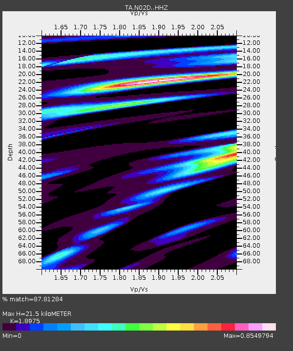
| Estimated Moho Depth: |
21.5 km |
| Estimated Crust Vp/Vs: |
1.90 |
| Assumed Crust Vp: |
6.566 km/s |
| Estimated Crust Vs: |
3.46 km/s |
| Estimated Crust Poisson's Ratio: |
0.31 |
|
| Radial Match: |
87.81284 % |
| Radial Bump: |
350 |
| Transverse Match: |
82.81191 % |
| Transverse Bump: |
400 |
| SOD ConfigId: |
7422571 |
| Insert Time: |
2019-04-22 03:35:12.294 +0000 |
| GWidth: |
2.5 |
| Max Bumps: |
400 |
| Tol: |
0.001 |
|
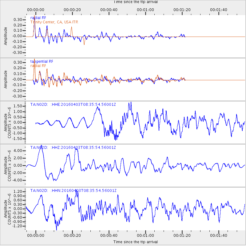
Signal To Noise
| Channel | StoN | STA | LTA |
| TA:N02D: :HHZ:20160403T08:35:54.56001Z | 13.517356 | 3.258203E-6 | 2.410385E-7 |
| TA:N02D: :HHN:20160403T08:35:54.56001Z | 2.5309467 | 5.5297403E-7 | 2.1848506E-7 |
| TA:N02D: :HHE:20160403T08:35:54.56001Z | 3.8462715 | 9.289687E-7 | 2.4152448E-7 |
| Arrivals |
| Ps | 3.0 SECOND |
| PpPs | 9.3 SECOND |
| PsPs/PpSs | 12 SECOND |


