You are here: Home > Network List > TA - USArray Transportable Network (new EarthScope stations) Stations List
> Station O02D Mt. Diablo Meridian, CA, USA > Earthquake Result Viewer
O02D Mt. Diablo Meridian, CA, USA - Earthquake Result Viewer
| Earthquake location: |
Vanuatu Islands |
| Earthquake latitude/longitude: |
-14.4/166.8 |
| Earthquake time(UTC): |
2016/04/03 (094) 08:23:53 GMT |
| Earthquake Depth: |
35 km |
| Earthquake Magnitude: |
6.9 MWW, 7.2 MI |
| Earthquake Catalog/Contributor: |
NEIC PDE/NEIC COMCAT |
|
| Network: |
TA USArray Transportable Network (new EarthScope stations) |
| Station: |
O02D Mt. Diablo Meridian, CA, USA |
| Lat/Lon: |
40.18 N/122.79 W |
| Elevation: |
965 m |
|
| Distance: |
84.8 deg |
| Az: |
46.449 deg |
| Baz: |
246.46 deg |
| Ray Param: |
0.045187157 |
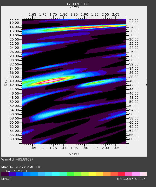
| Estimated Moho Depth: |
39.75 km |
| Estimated Crust Vp/Vs: |
1.74 |
| Assumed Crust Vp: |
6.566 km/s |
| Estimated Crust Vs: |
3.779 km/s |
| Estimated Crust Poisson's Ratio: |
0.25 |
|
| Radial Match: |
83.89627 % |
| Radial Bump: |
400 |
| Transverse Match: |
79.0045 % |
| Transverse Bump: |
400 |
| SOD ConfigId: |
7422571 |
| Insert Time: |
2019-04-22 03:35:14.956 +0000 |
| GWidth: |
2.5 |
| Max Bumps: |
400 |
| Tol: |
0.001 |
|

Signal To Noise
| Channel | StoN | STA | LTA |
| TA:O02D: :HHZ:20160403T08:35:52.680005Z | 23.276423 | 3.5436426E-6 | 1.5224173E-7 |
| TA:O02D: :HHN:20160403T08:35:52.680005Z | 1.9116516 | 5.954853E-7 | 3.1150304E-7 |
| TA:O02D: :HHE:20160403T08:35:52.680005Z | 3.7903483 | 7.492825E-7 | 1.9768169E-7 |
| Arrivals |
| Ps | 4.6 SECOND |
| PpPs | 16 SECOND |
| PsPs/PpSs | 21 SECOND |


